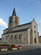
Luc-la-Primaube
| Luc-la-Primaube | ||
|---|---|---|
|
|
||
| region | Occitania | |
| Department | Aveyron | |
| Arrondissement | Rodez | |
| Canton | North Lévezou | |
| Community association | Rodez agglomeration | |
| Coordinates | 44 ° 19 ′ N , 2 ° 32 ′ E | |
| height | 514-740 m | |
| surface | 11.18 km 2 | |
| Residents | 5,969 (January 1, 2017) | |
| Population density | 534 inhabitants / km 2 | |
| Post Code | 12450 | |
| INSEE code | 12133 | |
| Website | www.luc-la-primaube.fr | |
 Luc-la-Primaube town hall |
||
Luc-la-Primaube ( Occitan Luc-La Primalba ) is a French municipality with 5969 inhabitants (as of January 1 2017) in the department of Aveyron in the region Occitania . It belongs to the Arrondissement of Rodez and the canton of North Lévezou . The inhabitants are called Lucois or Primaubois .
geography
The municipality is located between Toulouse and Lyon . The Brienne river limits the municipality to the north. Luc-la-Primaube is surrounded by the neighboring communities of Olemps in the north, Flavin in the east, Calmont in the south, Baraqueville in the west and Druelle Balsac with Druelle in the northwest. In addition to numerous smaller towns, the municipality mainly consists of the towns of Luc and La Primaube.
The national route 88 runs through the municipality .
history
Until 2005 the community was only called Luc after its main town.
Population development
| year | 1962 | 1968 | 1975 | 1982 | 1990 | 1999 | 2006 | 2011 |
| Residents | 1,428 | 1,864 | 2,613 | 3,674 | 4.036 | 4,717 | 5,258 | 5,685 |
Attractions
- Church in Luc from the 15th century with the bell tower from 1612
- Saint-Martin chapel , Gothic building from the 13th century
- 15th century Château de Planèzes
- Lake of Brienne ( Lac de la Brienne )


