
Mur-de-Barrez
|
Mur-de-Barrez Lo Mur de Barrés |
||
|---|---|---|
.svg)
|
|
|
| region | Occitania | |
| Department | Aveyron | |
| Arrondissement | Rodez | |
| Canton | Aubrac and Carladez | |
| Community association | Aubrac, Carladez et Viadène | |
| Coordinates | 44 ° 51 ′ N , 2 ° 40 ′ E | |
| height | 653-953 m | |
| surface | 20.18 km 2 | |
| Residents | 759 (January 1, 2017) | |
| Population density | 38 inhabitants / km 2 | |
| Post Code | 12600 | |
| INSEE code | 12164 | |
| Website | Mur-de-Barrez | |
 Mur-de-Barrez - aerial view |
||

Mur-de-Barrez ( Occitan : Lo Mur de Barrés ) is a place and a municipality in the south of France with 759 inhabitants (as of January 1, 2017) in the north of the Aveyron department in the Occitania region . The place belongs to the historical province of Rouergue .
location
The place Mur-de-Barrez is at an altitude of about 790 m above sea level. d. M .; the river Bromme flows through the municipality. Rodez , the former capital of the Rouergue, is about 82 km (driving distance) south; the small town of Aurillac is about 38 km northwest.
Population development
| year | 1800 | 1851 | 1901 | 1954 | 1999 | 2013 |
| Residents | 981 | 1,567 | 1,470 | 1,298 | 880 | 791 |
The increase in population in the first half of the 19th century is due to the incorporation of the formerly independent villages Bromme , La Salesse and Yolet . The population decline in the 20th century is mainly related to job losses as a result of the mechanization of agriculture .
economy
The town Mur-de-Barrez served for a long time the only agriculturally oriented and largely self-sufficient villages ( hamlets ) and individual farms in the area as a craft, trade and service center. Since the middle of the 20th century tourism has played a not insignificant role for the economic life of the place in the form of the rental of holiday apartments ( gîtes ).
history
Near the 11th century castle, the foundation walls of a manor ( mas ) from Carolingian times were exposed. The place names Castrum de Muro and Bastide de Muro have been handed down from the late Middle Ages . Under the Vice Counts of Carlat, the Barrez formed part of the Carladez , part of the Rouergue, which in turn was part of the Kingdom of Mallorca from 1276 to 1344 . During the Hundred Years' War (1337-1453) the castle and the place were attacked twice by irregulars . In the years 1435/40 time the city wall ( remparts ) was built, but almost nothing has survived, because in 1607 King Henry IV ordered its demolition, but it was not until 1620 under Louis XIII. was executed. In 1643 he gave the Carladez as a fief to the Monaco-based Grimaldi family , who ruled until the French Revolution .
Attractions

- Mur-de-Barrez
- The medieval-looking streets and alleys of Mur-de-Barrez with their houses made of natural stone are very charming.
- The parish church of Saint-Thomas-de-Cantorbéry was originally a 12th century building; however, it was given rib vaults in 1436 . In 1546 Cardinal Georges d'Armagnac elevated it to the rank of collegiate church ( collégiale ), but a few decades later (1590) it suffered considerable damage during an attack by the Huguenots . In 1635 the choir area was expanded and parts of the vaults were painted in the Baroque period . The church has been recognized as a monument historique since 1932 .
- The Tour de Monaco , built on a square floor plan and with the exception of the well-built corner stones and the archway of rubble stones , is the last remnant of the former city wall. There was once a guardroom above the gateway. It has been classified as a Monument historique since 1913 .
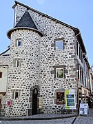
- A renaissance house resting on arcades from 1575 with several cross-frame windows served as a police station in the 19th century and from 1870 to 2000 as a monastery for some Franciscan women . It has also been classified as a Monument historique since 1929 .
- The Poor Clare Monastery ( Monastère Sainte-Claire ) was built in 1651 and is still used by nuns - with interruptions during and after the French Revolution .

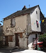
Porte de la Berque

Porte de la Berque
Maison
Maison

Maison Renaissance

Monastère Sainte-Claire


- Bromme
- The Romanesque church of Saint-Martin ( 44 ° 53 ′ 2 ″ N , 2 ° 40 ′ 19 ″ E ) is barrel vaulted inside; the apse has the usual dome vault . The church has been recognized as a monument historique since 1930 .
- Venzac
- The Château de Venzac ( 44 ° 52 ′ 1 ″ N , 2 ° 39 ′ 51 ″ E ) was probably originally a medieval manor ( mas ); the current building complex probably dates from the 16th / 17th centuries. Century. In addition to the main building, the former castle chapel has also been preserved. Parts of the structure have been recognized as Monuments historiques since 1989 . The garden of the country castle has been classified separately as a monument historique since 1995 .
Personalities
- Bernart de Venzac (around 1200), troubadour , may have been born in Venzac Castle.
literature
- Christophe Bellat: Mur-de-Barrez en Carladez. Au fil de l'histoire. Mur-de-Barrez, self-published 2002
Web links
- Mur-de-Barrez, history and monuments - photos + info (French)
- Mur-de-Barrez, Maison Renaissance - aerial view, photo + brief information (French)
- Mur-de-Barrez, Église Saint-Thomas-de Cantorbéry - aerial view, photo + brief information (French)
- Mur-de-Barrez, Tour Monaco - aerial view, photo + brief information (French)
- Mur-de-Barrez, Château de Venzac - aerial view, photo + brief information (French)
- Mur-de-Barrez, Church of Bromme - aerial photo + brief information (French)
Individual evidence
- ↑ Église Saint-Thomas-de-Cantorbéry, Mur-de-Barrez in the Base Mérimée of the French Ministry of Culture (French)
- ↑ Vieille tour servant de porte de ville, Mur-de-Barrez in the Base Mérimée of the French Ministry of Culture (French)
- ↑ Maison Renaissance, Mur-de-Barrez in the Base Mérimée of the French Ministry of Culture (French)
- ↑ Église Saint-Martin, Mur-de-Barrez in the Base Mérimée of the French Ministry of Culture (French)
- ↑ Château de Venzac, Mur-de-Barrez in the Base Mérimée of the French Ministry of Culture (French)
- ↑ Château de Venzac, Mur-de-Barrez in the Base Mérimée of the French Ministry of Culture (French)