Saint-Christophe-Vallon
|
Saint-Christophe-Vallon Sent Cristòfa |
||
|---|---|---|
|
|
||
| region | Occitania | |
| Department | Aveyron | |
| Arrondissement | Rodez | |
| Canton | Vallon | |
| Community association | Conques-Marcillac | |
| Coordinates | 44 ° 28 ′ N , 2 ° 25 ′ E | |
| height | 269-585 m | |
| surface | 23.22 km 2 | |
| Residents | 1,138 (January 1, 2017) | |
| Population density | 49 inhabitants / km 2 | |
| Post Code | 12330 | |
| INSEE code | 12215 | |
| Website | http://www.saintchristophevallon.fr/ | |
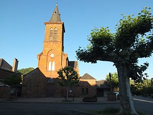
 Saint-Christophe Church |
||
Saint-Christophe-Vallon ( Occitan : Sent Cristòfa ) is a French commune in the Aveyron department in the Occitania region (before 2016: Midi-Pyrénées ) with 1,138 inhabitants (as of January 1, 2017). The municipality belongs to the arrondissement of Rodez and the canton of Vallon (until 2015: canton of Marcillac-Vallon ). The inhabitants are called Saint-Christophorois .
geography
Saint-Christophe-Vallon is located in the Marcillac wine-growing region , part of the Sud-Ouest wine-growing region . The Riou Mort river has its source on the western municipal boundary. Saint-Christophe-Vallon is surrounded by the neighboring communities of Saint-Cyprien-sur-Dourdou in the north, Nauviale in the northeast, Marcillac-Vallon in the east, Valady in the southeast, Goutrens in the south and southwest, Escandolières in the west and Auzits in the northwest.
history
The parish was formed in 1856.
Population development
| 1962 | 1968 | 1975 | 1982 | 1990 | 1999 | 2006 | 2013 |
|---|---|---|---|---|---|---|---|
| 742 | 778 | 882 | 920 | 868 | 1.002 | 1,046 | 1,129 |
| Source: Cassini and INSEE | |||||||
Attractions
- Saint-Christophe Church
