
Saint-Cyprien-sur-Dourdou
| Saint-Cyprien-sur-Dourdou | ||
|---|---|---|

|
|
|
| local community | Conques-en-Rouergue | |
| region | Occitania | |
| Department | Aveyron | |
| Arrondissement | Villefranche-de-Rouergue | |
| Coordinates | 44 ° 33 ' N , 2 ° 25' E | |
| Post Code | 12320 | |
| Former INSEE code | 12218 | |
| Incorporation | January 1, 2016 | |
| status | Commune déléguée | |
 former town hall (Mairie) of Saint-Cyprien-sur-Dourdou |
||

Saint-Cyprien-sur-Dourdou is a village and a former French commune with 894 inhabitants (as of January 1, 2017) in the Aveyron department in the Occitanie region . It belonged to the Arrondissement of Rodez and the canton of Lot et Dourdou . The inhabitants are called Cypriennois .
With effect from 1 January 2016, the former municipalities were Conques , Noailhac , Saint-Cyprien-sur-Dourdou and Grand-Vabre to nouvelle commune named Conques-en-Rouergue merged and have in the new community the status of a Déléguée commune held . The administrative headquarters are in Conques.
geography
Saint-Cyprien-sur-Dourdou is located about 24 kilometers north-northwest of Rodez on the Dourdou de Conques River . The village is located in the Marcillac wine-growing region .
Population development
| year | 1962 | 1968 | 1975 | 1982 | 1990 | 1999 | 2006 | 2013 |
| Residents | 1,020 | 925 | 863 | 849 | 778 | 766 | 794 | 865 |
| Source: Cassini and INSEE | ||||||||
Attractions
- Arjac Church from the 15th century
- Romanesque church of Saint-Cyprien from the 15th century
- Saint-Julien church in Malmont, built in the 12th century, alterations from the 18th century
- Le Cayla Castle from the 12th century, alterations from the 16th century
- Sanhes Mill
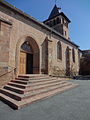
Saint-Cyprien Church

Sanhes Mill

_146.JPG)