Dourdou de Conques
| Dourdou de Conques | ||
|
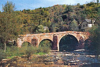
Pilgrim Bridge at Conques |
||
| Data | ||
| Water code | FR : O80-0400 | |
| location | France , Occitania region | |
| River system | Garonne | |
| Drain over | Lot → Garonne → Atlantic Ocean | |
| source | in the Massif Central , in the municipality of Lassouts 44 ° 29 ′ 14 ″ N , 2 ° 51 ′ 28 ″ E |
|
| Source height | 660 m | |
| muzzle | at Grand-Vabre in the Lot coordinates: 44 ° 38 ′ 10 ″ N , 2 ° 21 ′ 15 ″ E 44 ° 38 ′ 10 ″ N , 2 ° 21 ′ 15 ″ E |
|
| Mouth height | 190 m | |
| Height difference | 470 m | |
| Bottom slope | 5.6 ‰ | |
| length | 84 km | |
| Left tributaries | Créneau | |
The Dourdou de Conques river has its source in the Massif Central , on the Puy de Calme , in the municipality of Lassouts . It flows into the Lot as a left tributary at Grand-Vabre after 84 kilometers .
Places on the river
Pilgrim bridge
At Conques, the Via Podiensis crosses the river, a French section of the Camino de Santiago to Santiago de Compostela . The old stone bridge with its five arches is therefore also called the pilgrim bridge . Although it is often said to be of Roman origin, based on its construction, it must be assumed that it was built between the 14th and 17th centuries. However, since pilgrimages at this point have been documented since the 11th century, it can be assumed that it replaced a previous building.
Since 1998, the bridge has been listed as part of the UNESCO World Heritage “Camino de Santiago in France”.
Trou de Bozouls
In the town of Bozouls , the Dourdou has cut a horseshoe-shaped ravine about 100 meters, which is called "the Bozouls Hole" in French.
Web links
Remarks
- ↑ The information on the length of the river is based on the information on the relevant website sandre.eaufrance.fr/ , accessed on April 24, 2009.


