Boralde de Saint-Chély-d'Aubrac
| Boralde de Saint-Chély-d'Aubrac | ||
|
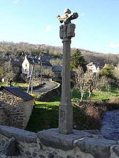
Pilgrim cross on the bridge in Saint-Chély-d'Aubrac |
||
| Data | ||
| Water code | FR : O7240520 | |
| location | France , Occitania region | |
| River system | Garonne | |
| Drain over | Lot → Garonne → Atlantic Ocean | |
| source | in the municipality of Saint-Chély-d'Aubrac, 44 ° 35 ′ 57 ″ N , 3 ° 1 ′ 26 ″ E |
|
| Source height | approx. 1320 m | |
| muzzle | at Saint-Côme-d'Olt in the Lot coordinates: 44 ° 30 ′ 47 " N , 2 ° 50 ′ 37" E 44 ° 30 ′ 47 " N , 2 ° 50 ′ 37" E |
|
| Mouth height | approx. 350 m | |
| Height difference | approx. 970 m | |
| Bottom slope | approx. 39 ‰ | |
| length | 25 km | |
The Boralde de Saint-Chély-d'Aubrac is a small French river in the Aveyron department in the Occitanie region . It rises in the municipality of Saint-Chély-d'Aubrac and flows into the Lot after around 25 kilometers just above Saint-Côme-d'Olt as a right tributary . The river forms several waterfalls, the most famous of which is the Cascade des Touzes , and it crosses the municipalities of Saint-Chély-d'Aubrac, Castelnau-de-Mandailles and Saint-Côme-d'Olt.
Way of St. James
The pilgrims who travel along the Via Podiensis follow the Boralde de Saint-Chély-d'Aubrac, and cross it on the so-called pilgrim bridge at Saint-Chély. This is since 1998 as a UNESCO World Heritage of UNESCO as part of the " Camino de Santiago protected in France."
Individual evidence
- ↑ a b geoportail.fr (1: 16,000)
- ↑ a b The information on the length of the river is based on the information about the Boralde de Saint-Chély-d'Aubrac near SANDRE (French), accessed on June 1, 2011, rounded to full kilometers.

