
Bertholène
|
Bertholène Bertolena |
||
|---|---|---|
.svg)
|
|
|
| region | Occitania | |
| Department | Aveyron | |
| Arrondissement | Rodez | |
| Canton | Lot et Palanges | |
| Community association | Causses à l'Aubrac | |
| Coordinates | 44 ° 24 ' N , 2 ° 47' E | |
| height | 533-926 m | |
| surface | 46.96 km 2 | |
| Residents | 1,046 (January 1, 2017) | |
| Population density | 22 inhabitants / km 2 | |
| Post Code | 12310 | |
| INSEE code | 12026 | |

Bertholène ( Occitan Bertolena ) is a French commune with 1,046 inhabitants (as of January 1, 2017) in the Aveyron department in the Occitania region (before 2016 Midi-Pyrénées ). Administratively it belongs to the Arrondissement of Rodez and is part of the canton of Lot et Palanges (until 2015 Laissac ). The inhabitants are called Bertholénois .
geography
Bertholène is located about 17 kilometers east-northeast of Rodez on the Aveyron . Bertholène is surrounded by the neighboring communities of Gabriac in the north, Palmas d'Aveyron in the east and northeast, Laissac-Sévérac l'Église in the east and southeast, Arques in the south and southeast, Le Vibal in the south and southwest, Montrozier in the west and Bozouls in the northwest .
The national route 88 runs through the municipality .
Population development
| year | 1962 | 1968 | 1975 | 1982 | 1990 | 1999 | 2006 | 2013 |
| Residents | 883 | 785 | 705 | 782 | 918 | 924 | 994 | 1021 |
| Source: Cassini and INSEE | ||||||||
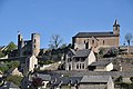
Attractions
- Bourines dolmen, a historic monument since 1995
- Saint-Amans church in Bertholène
- Saint-Julien church in Ayrinhac, Monument historique
- Saint Maurice Church in Anglars
- Bertholène castle ruins from the 12th century, monument historique since 1963
- Les Bourines Castle, Monument historique since 1995
- Le Touriol cave
Saint-Amans church

Saint-Julien church

Saint-Maurice Church

Bertholène castle ruins

Les Bourines Castle


.jpg)