
Coubisou
|
Coubisou Cobison |
||
|---|---|---|
|
||
| region | Occitania | |
| Department | Aveyron | |
| Arrondissement | Rodez | |
| Canton | Lot et Truyère | |
| Community association | Comtal Lot and Truyère | |
| Coordinates | 44 ° 33 ' N , 2 ° 44' E | |
| height | 319-836 m | |
| surface | 30.95 km 2 | |
| Residents | 492 (January 1, 2017) | |
| Population density | 16 inhabitants / km 2 | |
| Post Code | 12190 | |
| INSEE code | 12079 | |
 Town hall (Mairie) of Coubisou |
||

Coubisou ( Occitan Cobison ) is a French commune with 492 inhabitants (as of January 1, 2017) in the Aveyron département in the Occitania region (before 2016 Midi-Pyrénées ). Administratively it belongs to the Arrondissement of Rodez and is part of the canton of Lot et Truyère (to 2015 Estaing ). The inhabitants are called Coubisounels .
geography
Coubisou is located about 28 kilometers north-northeast of Rodez . Coubisou is surrounded by the neighboring municipalities of Le Nayrac in the north and northwest, Montpeyroux in the north and northeast, Le Cayrol in the east, Espalion in the east and southeast, Bessuéjouls in the south, Sébrazac in the southwest and Estaing in the west.
Population development
| year | 1962 | 1968 | 1975 | 1982 | 1990 | 1999 | 2006 | 2013 |
| Residents | 636 | 571 | 508 | 511 | 488 | 502 | 528 | 504 |
| Source: Cassini and INSEE | ||||||||
Attractions
- Saint-Védard church from the 12th century, renovations from the 15th century, monument historique since 1978
- Saint Martin Church in Nadaillac
- The 15th century monastery and church of Le Monastère-Cabrespines and the Notre-Dame-del-Boy chapel
- Cabrespines Castle from the 17th century
- Tourruol castle ruins from the 13th century
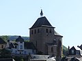
Saint-Védard church

Saint Martin Church

Monastery and church of Le Monastère-Cabrespines

Notre-Dame-del-Boy chapel

Cabrespines Castle
.jpg)


