
Assier
|
Assier Assièr |
||
|---|---|---|
.svg)
|
|
|
| region | Occitania | |
| Department | Lot | |
| Arrondissement | Figeac | |
| Canton | Lacapelle-Marival | |
| Community association | Grand Figeac | |
| Coordinates | 44 ° 41 ′ N , 1 ° 53 ′ E | |
| height | 294-420 m | |
| surface | 16.49 km 2 | |
| Residents | 651 (January 1, 2017) | |
| Population density | 39 inhabitants / km 2 | |
| Post Code | 46320 | |
| INSEE code | 46009 | |
 Assier - castle |
||

Assier (Occitan: Assièr ) is a southern French town and municipality ( commune ) with 651 inhabitants (as of January 1, 2017) in the Lot department in the Occitania region (previously Midi-Pyrénées ).
location
The place Assier is in the north of the Quercy at an altitude of about 350 m . It is a good 20 km (driving distance) to Figeac in a south-easterly direction; the important medieval pilgrimage site Rocamadour is about 33 km to the north-west. Assier has a train station on the Brive - Rodez line . The municipality is part of the Causses du Quercy Regional Nature Park . The climate is temperate; Rain falls throughout the year.
Population development
| year | 1800 | 1851 | 1901 | 1954 | 1999 | 2015 |
| Residents | 655 | 812 | 736 | 622 | 535 | 669 |
The slight population decline since the middle of the 19th century is mainly due to the mechanization of agriculture and the abandonment of small farms.
economy
The place was always characterized by agriculture; the residents lived as self-sufficient . However, the stony and calcareous soils of the Causses are not suitable for growing grain and so almost all remaining farmers in the late 19th and early 20th centuries gradually switched to dairy and cattle farming, with sheep breeding playing an important role. In the 1970s and 1980s, several houses in the village were converted into holiday apartments ( gîtes ).
history


There seem to have been permanent human settlements in the area as early as the Neolithic ; Remains from this era are some large stone graves ( dolmens ) and a menhir in the east and northeast of the village.
The Celts and Romans have left no traces and so the history of today's place begins with a fortified settlement ( bourg castral ) from the Middle Ages, in the center of which was the castle of the local landlord ( seigneur ); Small parts of the Tour du Sal have been preserved from this castle . In the 13th century Assier became dependent on the knightly order of St. John of Jerusalem ( Order of Malta ), who subsequently built a fortified commandery with a church, a hospital and a - outside - leprosy station in Assier . During the Hundred Years War (1337-1453), the Quercy was the scene of a large number of politically or economically motivated attacks - for example, bands of robbers made up of former rioters made the area unsafe for a long time.
A man whose name remains inextricably linked to local history is Jacques Ricard de Genouillac, born in Assier, known as Galiot de Genouillac (1465–1546), who ruled under three French kings ( Charles VIII , Louis XII and Francis I ). held the highest state offices and is regarded as a diplomat of European rank. Around 1525 he had the old manor, in which he saw the light of day, torn down; ten years later he began building a new four-wing palace in the Renaissance style , of which only one wing has survived. From 1540 he had the Saint-Pierre church built, which he designated as his church of the Holy Sepulcher. His son was fatally wounded in the Battle of Ceresole (1544); he had a grandson of his daughter who was murdered on St. Bartholomew's Night (1572).
The Wars of Religion (1562–1598) also wreaked havoc in Assier, whereas the events of the French Revolution left hardly any traces in the south of France. As early as 1788, the notary Jean-Pierre Séguy had acquired parts of the manor over Assier, which he later gave away to the residents, so that each resident of the place was allocated at least 34 ares . From 1801 to 1827 Jean-Pierre Séguy was elected mayor of the place several times in a row.
The 19th and early 20th centuries saw fundamental improvements in the infrastructure (railways, road construction, electrification, water supply), in the school system as well as in poor and sick care. In 1834 an elementary school for boys was set up, where learning to read cost 1 franc a year; Reading and writing cost 1.50 francs and arithmetic 2 francs. Twelve students from poor families were taught free of charge. In 1902 a primary school for girls followed and in 1905 general and free schooling was introduced.
Attractions
Assier Castle
with pigeon tower
Saint-Pierre church
Others

- A residential building ( logis ) from the 16th century, which was later used as a barn ( Grange de Bargues ) , belonged to the former castle grounds . The building was classified as a monument historique in 2001 .
- A pigeon house ( pigeonnier ) from the 16th century that was formerly part of the castle was recognized as a monument historique in 2005 .
- Surroundings
- That around 3000 BC The megalithic tomb ( dolmen ) Bois de Boeufs was built in 1889 and entered the list of Monuments historiques . The Dolmen Table Roux and Champ de Belair are also on the territory of the municipality.
- In the nearby hamlet of Mons there is another pigeon house from the 17th or 18th century.
- In the karst surroundings of the Causses du Quercy there are two stalactite caves - the Grotte de Cirque and the Grotte du Fennet .

La Grotte du Cirque

Dolmen Bois de Boeufs

Dolmen du Champ de Belair
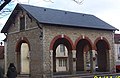
Market hall (1884)


Web links
Individual evidence
- ↑ Assier - Map with altitude information
- ↑ Assier - Climate tables
- ↑ Ancien logis "Grange de Bargues", Assier in the Base Mérimée of the French Ministry of Culture (French)
- ↑ Ancien Pigeonnier du Château, Assier in the Base Mérimée of the French Ministry of Culture (French)
- ↑ Dolmen Bois de Boeufs, Assier in the Base Mérimée of the French Ministry of Culture (French)