
Terrou
|
Terrou Terron |
||
|---|---|---|
|
||
| region | Occitania | |
| Department | Lot | |
| Arrondissement | Figeac | |
| Canton | Lacapelle-Marival | |
| Community association | Grand Figeac | |
| Coordinates | 44 ° 47 ' N , 1 ° 59' E | |
| height | 280-535 m | |
| surface | 9.94 km 2 | |
| Residents | 168 (January 1, 2017) | |
| Population density | 17 inhabitants / km 2 | |
| Post Code | 46120 | |
| INSEE code | 46314 | |

Terrou ( Occitan : Terron ) is a French municipality with 168 inhabitants (at January 1, 2017) in the department of Lot in the Région Okzitanien (2015 Midi-Pyrenees ). It belongs to the arrondissement of Figeac and to the community association Grand-Figeac founded in 2016 . The inhabitants are called Terronais .
In 1925, Ladirat was spun off from Terrou as a new independent municipality.
geography
The community is located about 27 kilometers north of Figeac in the east of the Quercy landscape in the southwestern foothills of the Massif Central . The upper Bave flows through the municipal area of almost ten square kilometers . The landscape is characterized by mountain forests, deeply cut valleys and pastures on the mountain slopes. The largest districts of the municipality of Terrou are La Mazet, Le Montet, Nozières, Jauzac, La Tournerie, Las Descargues, Chapert and Sasmayoux . The highest point in the municipality is a 571 m high ridge near the hamlet of Las Bouygues in the southwest of the municipality. Terrou is bounded by the neighboring municipalities of Ladirat in the north, Gorses in the east, Saint-Médard-Nicourby and Labathude in the south-east, Saint-Maurice-en-Quercy in the south, Espeyroux in the south-west and Molières in the west.
Place name
The place name Terrou could be based on the Occitan Teron (= well or spring ). The Occitan word Terron (= parcel ) allows another interpretation .
Population development
| year | 1962 | 1968 | 1975 | 1982 | 1990 | 1999 | 2006 | 2016 |
| Residents | 291 | 271 | 253 | 214 | 197 | 202 | 202 | 171 |
| Sources: Cassini and INSEE | ||||||||
Attractions
- Saint-Pierre-ès-Liens church
- Saint-Thamar castle northwest of the village from the 15th to 18th centuries, monument historique
- Sarcophagus of a necropolis from the High Middle Ages west of the village of Terrou, excavated and researched between 1984 and 1986
- Fallen memorial
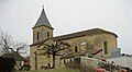
Saint-Pierre-ès-Liens church

sarcophagus
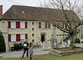
Elementary school and memorial for favor


Economy and Infrastructure
There are 24 farms in the municipality of Terrou (grain cultivation, dairy farming, horse, cattle, goat and sheep breeding).
Terrou is located away from the nationally important traffic routes, but is connected to all neighboring communities by country roads. In the town of Figeac , 27 kilometers south of Terrou, several highways meet. In Montfaucon , 50 kilometers to the west, there is a connection to the ( Autoroute A20 ). In Assier , 18 kilometers southwest of Terrou, there is a stop on the railway line from Brive-la-Gaillarde via Capdenac to Toulouse ( Ligne de Brive-la-Gaillarde à Toulouse-Matabiau via Capdenac ).
supporting documents
- ↑ Ladirat on cassini.ehess.fr
- ↑ Gaston Bazalgues: À la découverte des noms de lieux du Quercy: Toponymie lotoise, Gourdon, Éditions de la Bouriane et du Quercy, June 2002, 127 pp. ( ISBN 2-910540-16-2 ), p. 124. (French )
- ↑ Terrou on cassini.ehess.fr
- ↑ Terrou on insee.fr
- ^ Entry in the Base Mérimée of the Ministry of Culture. Retrieved July 2, 2019 (French).
- ↑ Farms on annuaire-mairie.fr (French)