
Le Bourg
|
Le Bourg Lo Borg |
||
|---|---|---|
|
||
| region | Occitania | |
| Department | Lot | |
| Arrondissement | Figeac | |
| Canton | Lacapelle-Marival | |
| Community association | Grand Figeac | |
| Coordinates | 44 ° 43 ' N , 1 ° 54' E | |
| height | 336-565 m | |
| surface | 13.15 km 2 | |
| Residents | 331 (January 1, 2017) | |
| Population density | 25 inhabitants / km 2 | |
| Post Code | 46120 | |
| INSEE code | 46034 | |
 Le Bourg - the village with the Francès river |
||

Le Bourg ( Occitan : Lo Borg ) is a southern French municipality with 331 inhabitants (as of January 1, 2017) in the Lot department in the Occitanie region . The municipality is part of the Causses du Quercy Regional Nature Park .
location
Le Bourg lies at an altitude of approx. 350 meters above sea level. d. M. on the southwestern edge of the Massif Central, roughly on the border between the fertile Limargue region and the very different limestone soils of the Ségala . The place is located on a branch of the Way of St. James ( Via Podiensis ) about halfway between Rocamadour or Gramat and Figeac ; the city of Cahors is about 63 kilometers southwest.
Population development
| year | 1962 | 1968 | 1975 | 1982 | 1990 | 1999 | 2006 |
| Residents | 273 | 228 | 218 | 222 | 229 | 246 | 281 |
In the first half of the 19th century the place always had between 600 and 750 inhabitants. As a result of the phylloxera crisis in viticulture and the mechanization of agriculture , the number of inhabitants then fell continuously to the lows in the 1960s and 1970s.
economy
In the Haut-Quercy , agriculture was primarily self-sufficient , which also included viticulture until the 19th century, but which was almost completely abandoned after the phylloxera crisis . Today - in addition to agriculture, retail trade and handicrafts - tourism in the form of renting holiday apartments ( gîtes ) plays a major role in the economic life of the municipality.
history
The foundation of a priory by the abbey of Aurillac is closely related to the origin of the place . In the 16th century, the church and town were destroyed during the Huguenot Wars (1562–1598). In 1823 the nearby municipality of Saint-Médard-la-Garénie was dissolved; their area was added to the municipalities of Issepts and Le Bourg. In May 1944 a department of the SS division 'Das Reich' deported 13 men from the village, four of whom did not return.
Attractions

- The remaining parts ( transept , apses ) of the former priory church and today's parish church of Saint-Saturnin are assigned to the late 11th and early 12th centuries. The three-aisled nave was destroyed in the 16th century and not rebuilt; today's entrance and the tower-like attachment for the bells date from this time. In the crossing area and in the choir , the creative will and the craftsmanship of the medieval builders can be clearly seen: the lower level is formed by arcades with large and richly decorated capitals ; Above that, in the semicircle of the apse, there is a window zone and the precisely bricked apse vault in the form of a semi-dome. The choir bay shows a second arcade position in the upper area and ends with a barrel vault . Above the triumphal arch to the apse there are three small windows whose 'vault' (so-called 'bishop's hats') consists of slanted stone slabs. The church building was classified as a monument historique in 1986 .
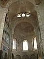
dto.

Capital with braided ribbon and pine cones

Vegetable capital with head motif and braided band on the fighter plate


- A water mill was built over the Francès stream .
- Several stone crosses are in the place or in the area
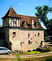
Watermill
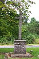
Stone cross near the church

crossroads

crossroads


Web links
Individual evidence
- ↑ Église Saint-Saturnin, Le Bourg in the Base Mérimée of the French Ministry of Culture (French)