Beauregard (Lot)
| Beauregard | ||
|---|---|---|
|
|
||
| region | Occitania | |
| Department | Lot | |
| Arrondissement | Cahors | |
| Canton | Marches du Sud-Quercy | |
| Community association | Pays de Lalbenque-Limogne | |
| Coordinates | 44 ° 21 ′ N , 1 ° 48 ′ E | |
| height | 298-396 m | |
| surface | 15.30 km 2 | |
| Residents | 233 (January 1, 2017) | |
| Population density | 15 inhabitants / km 2 | |
| Post Code | 46260 | |
| INSEE code | 46020 | |
 Place view |
||
The southern French municipality of Beauregard ( Occitan Bèlregard ) is located in the Lot department in the Occitanie region (previously Midi-Pyrénées ). The municipality with 233 inhabitants (as of January 1, 2017) is part of the Causses du Quercy Regional Nature Park .
location
Beauregard lies at an altitude of about 370 meters above sea level. d. M. on the southwestern edge of the Massif Central in the area of the Causse de Limogne . The nearest town, Cahors , is about 37 kilometers (driving distance) to the northwest. The next larger town, about eight kilometers away, is Limogne-en-Quercy .
Population development
| year | 1962 | 1968 | 1975 | 1982 | 1990 | 1999 | 2006 |
| Residents | 225 | 217 | 177 | 167 | 184 | 188 | 236 |
Until the middle of the 19th century, the place always had between 800 and 900 inhabitants. As a result of the phylloxera crisis in viticulture and the mechanization of agriculture , the number of inhabitants has steadily declined since the second half of the 19th century to its lowest level in the 1980s.
economy
In the Haut-Quercy agriculture was traditionally practiced, which also included viticulture until the 19th century, but which was almost completely abandoned after the phylloxera crisis. Today - in addition to cattle and poultry farming - tourism in the form of renting holiday apartments ( gîtes ) plays a major role in the economic life of the municipality.
history
Beauregard is close to the Roman road from Cahors ( Divona Cadurcorum ) to Rodez ( Ruthena civitas ) and was in the 13th century as a joint project ( paréage ) and as Bastide by the Benedictine -Abtei of Marcilhac-sur-Cele and the French king Philip IV. Founded .
Attractions
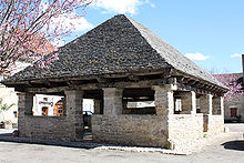
- The market hall, which dates back to the 15th century, is made of rubble stones and covered by a wooden roof structure with thin stone slabs ( lauzes ). In the outer wall there are some stones that were used as grain gauges. The building was recognized as a monument historique as early as 1922 .
- An unusual stone tree cross from the 15th century was placed under protection in 1959.
- The privately owned Château de Labastide is about a kilometer west of the village. The complex is made up of components from the 13th, 15th and 17th centuries; he has a pigeon house ( colombier ) and was recognized in 1979 as a monument historique .
- A nearby cave ( Igue de la Vayssière ) has been explored several times by cave explorers in recent years.
- The dolmen in the Bois de Beauregard
Web links
Individual evidence
- ^ Halle, Beauregard (Lot) in the Base Mérimée of the French Ministry of Culture (French)
- ↑ Croix-en-pierre, Beauregard (Lot) in the Base Mérimée of the French Ministry of Culture (French)
- ↑ Château de Labastide, Beauregard (Lot) in the Base Mérimée of the French Ministry of Culture (French)

