
Castelfranc
| Castelfranc | ||
|---|---|---|
|
||
| region | Occitania | |
| Department | Lot | |
| Arrondissement | Cahors | |
| Canton | Luzech | |
| Community association | Vallée du Lot et du Vignoble | |
| Coordinates | 44 ° 30 ′ N , 1 ° 13 ′ E | |
| height | 80-270 m | |
| surface | 5.71 km 2 | |
| Residents | 426 (January 1, 2017) | |
| Population density | 75 inhabitants / km 2 | |
| Post Code | 46140 | |
| INSEE code | 46062 | |
| Website | www.castelfranc.fr | |
 Mayor's office ( Mairie ) and parish church |
||

Castelfranc is a French commune with 426 inhabitants (as of January 1, 2017) in the Lot department in the Occitanie region (before 2016: Midi-Pyrénées ). The municipality belongs to the arrondissement of Cahors and the canton of Luzech .
The beginning of the name of the municipality "Castel" refers to an earlier castellum , a fortress made of wood or stone. The ending "Franc" has the meaning of the Middle Ages "free". This adjective was given in the Middle Ages to villages that were founded by royal or religious authorities. In order to attract new residents, special privileges were granted or exemptions from taxes or duties were promised.
The inhabitants are called Castelfrancois and Castelfrancoises .
geography
Castelfranc is about 18 kilometers west-northwest of Cahors in the historic province of Quercy .
Castelfranc is surrounded by the six neighboring municipalities:
| Les Junies | Labastide-du-Vert | |
| Prayssac |
.svg)
|
Luzech |
| Anglars-Juillac | Albas |
Castelfranc lies in the catchment area of the Garonne River on the right bank of the Lot . One of its tributaries, the Vert , crosses the territory of the municipality together with its tributary, the Ruisseau de la Masse.
history
Castelfranc was founded as a bastide at the end of the 12th century on the initiative of the Bishops of Cahors to defend the valleys of the Vert and the Mass.
Population development
After records began, the population rose to a peak of 855 by the first half of the 19th century. In the following period, the size of the community fell to around 315 inhabitants with brief recovery phases up to the 1980s, before a phase of growth set in that the Number of inhabitants stabilized at a level of around 400 inhabitants.
| year | 1962 | 1968 | 1975 | 1982 | 1990 | 1999 | 2006 | 2011 | 2017 |
|---|---|---|---|---|---|---|---|---|---|
| Residents | 361 | 356 | 341 | 317 | 365 | 413 | 422 | 392 | 426 |

Attractions
Parish Church of Notre-Dame
The church was believed to have been built a little later than the foundation of the bastide in the mid-13th century. The sculptural work on the unadorned capitals at the entrance portal allows it to be dated to the years 1260 to 1270. The rose window in the facade above the portal was probably made no earlier than 1280 to 1290, because its pattern corresponds to that of the cathedral of Cahors. While the apse was the result of the same building activity, the nave was almost completely rebuilt in the 19th century. The church is located on the corner of the central square according to the plan of a bastide in a block and keeps with it a northeast-southwest orientation . The west facade is framed by two wide but thin support pillars . It runs up into a bell gable with four recesses for the bells, the side roof structures of which are supported by the console and thus give the gable a defensive appearance. A polygonal stair tower on the north side allows access. The quadrangular apse supports a bell tower that is only one storey higher. It has support pillars on its outer corners. The apse is equipped with a ribbed vault with colored painted ribs. A quatrefoil and the black band of a liter funéraire painted on the stone can be seen on the inside walls above the closet . A narrow side chapel adjoins the south side of the single nave nave , which together with a polygonal chapel with support pillars arranged in a radial pattern on the north side forms a false transept. The capitals of the entrance portal are decorated with small human heads on the left and flowers and leaves with a simple pattern on the right. The keystone of the apse bears the mark of Agnus Dei . The west facade of the church has been classified as a Monument historique since November 20, 1920 .
A large number of furnishings from the 15th to 18th centuries are inscribed as a monument historique of movable goods.

Parish Church of Notre-Dame , west facade
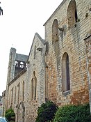
Southeast facade

View of the chancel in the nave

North side chapel

Vault of the apse

Virgin Mary statue with two angels

Oil painting depicting the Ascension of Johannes Gabriel Perboyre


Dolmen
There are numerous dolmens in the municipality , including the Los-Très-Peyros dolmen, also known as the Causse de Cousis dolmen, and the Pech de Roquebert dolmen.
Economy and Infrastructure

Blue cheese Bleu des Causses

AOC Cahors grapevine

Rocamadour cheese


Castelfranc is in the AOC zones
- the blue cheese Bleu des Causses ,
- of the Cahors wine,
- des Rocamadour , a cheese made from goat's milk ,
- the Noix du Périgord , the walnuts of the Périgord , and
- of the Périgord nut oil.

total = 39
education
The community has a public primary school.
sport and freetime
The GR 36, a long-distance hiking trail from Ouistreham in the Calvados department to Bourg-Madame in the Pyrénées-Orientales department , crosses the municipality's territory.
traffic
Castelfranc can be reached via Routes départementales 9, 37, 45, 50 and 811, the former Route nationale 111 .
The commune is also connected to other communes in the department by a line from the Lignes intermodales d'Occitanie bus network from Cahors to Monsempron-Libos .

Personalities
- Jean Lavayssière, born on November 23, 1821 in Castelfranc, died on July 4, 1892 in Castelfranc, was sergeant of the 8th Jäger Battalion and one of the few French soldiers who survived the battle of Sidi Brahim in 1845.
- Raoul Pierre Émile Combes, born January 15, 1883 in Castelfranc, died February 27, 1964 in Paris , was a botanist .
- Jean Milhau, born on December 18, 1929 in Castelfranc, is a pharmacist and French politician of the Parti radical de gauche . Among other things, he was President of the Départementrat des Départements from 1994 to 2004 and a member of the French Senate from 2008 to 2011 .
Web links
- Information about the blue cheese Bleu des Causses (French)
- Information about the Cahors wine (French)
- Information about the Rocamadour cheese (French)
- Information on Périgord walnuts and Périgord nut oil (French)
- Information about the Lignes intermodales d'Occitanie (LIO) (French)
Individual evidence
- ^ A b Jean-Marie Cassagne: Villes et Villages en pays lotois ( fr ) Tertium éditions. P. 68. 2013. Retrieved June 26, 2019.
- ↑ Lot ( fr ) habitants.fr. Retrieved June 25, 2019.
- ^ Ma commune: Castelfranc ( fr ) Système d'Information sur l'Eau du Bassin Adour Garonne. Retrieved June 26, 2019.
- ↑ Notice Communale Castelfranc ( fr ) EHESS . Retrieved June 25, 2019.
- ↑ Populations légales 2016 Commune de Castelfranc (46062) ( fr ) INSEE . Retrieved June 25, 2019.
- ↑ Gilles Séraphin, Maurice Scellés: glise paroissiale Notre Dame ( fr ) Départemental Lot. October 3, 2013. Retrieved June 26, 2019.
- ^ Eglise Notre-Dame de l'Assomption ( fr ) French Ministry of Culture . October 13, 2015. Accessed June 26, 2019.
- ↑ église Notre-Dame-de-l'Assomption ( fr ) French Ministry of Culture . Retrieved June 26, 2019.
- ↑ Institut national de l'origine et de la qualité: Rechercher un produit ( fr ) Institut national de l'origine et de la qualité . Retrieved June 25, 2019.
- ↑ Caractéristiques des établissements en 2015 Commune de Castelfranc (46062) ( fr ) INSEE . Retrieved June 25, 2019.
- ^ École élémentaire ( fr ) National Ministry of Education. Retrieved June 25, 2019.
- ↑ GR36 - Randonnée de Prayssac (Lot) à Savignac (Aveyron) ( fr ) gr-infos.com. Retrieved June 26, 2019.
- ↑ En mémoire du sergent Lavayssiere ( fr ) La Dépêche du Midi . March 23, 2015. Accessed June 26, 2019.
- ↑ Jean Lavayssiere (1821-1892) ( fr ) Bibliothèque nationale de France . Retrieved June 26, 2019.
- ↑ MILHAU Jean ( fr ) French Senate. Retrieved June 26, 2019.
- ^ Jean Milhau: "Je suis soulagé" ( fr ) La Dépêche du Midi . March 8, 2004. Retrieved June 26, 2019.