
Arcambal
|
Arcambal Arcambald |
||
|---|---|---|
|
||
| region | Occitania | |
| Department | Lot | |
| Arrondissement | Cahors | |
| Canton | Cahors-2 | |
| Community association | Grand Cahors | |
| Coordinates | 44 ° 27 ' N , 1 ° 31' E | |
| height | 110-342 m | |
| surface | 23.11 km 2 | |
| Residents | 994 (January 1, 2017) | |
| Population density | 43 inhabitants / km 2 | |
| Post Code | 46090 | |
| INSEE code | 46007 | |
 View of Arcambal |
||

Arcambal ( Occitan : Arcambald ) is a French commune in the Lot department in the Occitanie region (before 2016: Midi-Pyrénées ). The municipality with 994 inhabitants (as of January 1, 2017) belongs to the arrondissement of Cahors and the canton of Cahors-2 (until 2015: canton of Cahors-Sud ).
geography
Arcambal is about four kilometers east of the city center of Cahors on the southwestern edge of the Massif Central and the western edge of the Cevennes . The Lot delimits the municipality in the north. Arcambal is surrounded by the neighboring communities
- Saint Géry-Verse with verse in the north and Saint Géry-Verse with Saint-Géry in the northeast,
- Esclauzels in the east and southeast,
- Aujols in the south,
- Flaujac-Poujols in the southwest,
- Cahors in the west,
- Lamagdelaine in the northwest.
Population development
| 1962 | 1968 | 1975 | 1982 | 1990 | 1999 | 2006 | 2013 | |
|---|---|---|---|---|---|---|---|---|
| 410 | 409 | 413 | 535 | 637 | 735 | 821 | 1.007 | |
| Source: Cassini and INSEE | ||||||||
Attractions
- Saint-Antoine church from the 15th century
- Notre-Dame-de-l'Assomption church
- Le Bousquet Castle, historic monument since 1979
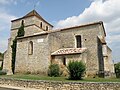
Saint-Antoine church

Le Bousquet Castle


Web links
Commons : Arcambal - collection of images, videos and audio files