Bardigues
|
Bardigues Bardigas |
||
|---|---|---|
|
|
||
| region | Occitania | |
| Department | Tarn-et-Garonne | |
| Arrondissement | Castelsarrasin | |
| Canton | Garonne Lomagne Brulhois | |
| Community association | Deux Rives | |
| Coordinates | 44 ° 2 ' N , 0 ° 53' E | |
| height | 77-185 m | |
| surface | 11.67 km 2 | |
| Residents | 296 (January 1, 2017) | |
| Population density | 25 inhabitants / km 2 | |
| Post Code | 82340 | |
| INSEE code | 82010 | |
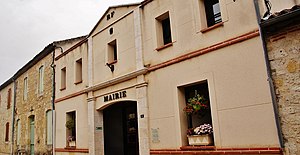
 Town Hall (Mairie) of Bardigues |
||
Bardigues ( Occitan Bardigas ) is a French commune in the Tarn-et-Garonne department in the Occitanie region (before 2016: Midi-Pyrénées ). The municipality with 296 inhabitants (as of January 1, 2017) is located in the arrondissement of Castelsarrasin and is part of the canton of Garonne-Lomagne-Brulhois (until 2015: canton of Auvillar ). The inhabitants are called Bardiguais .
geography
Bardigues is about 37 kilometers west of Montauban . Bardigues is surrounded by the neighboring communities of Auvillar in the north, Saint-Michel in the east and northeast, Castéra-Bouzet in the south and southeast, Mansonville in the west and southwest and Saint-Antoine in the west.
| year | 1962 | 1968 | 1975 | 1982 | 1990 | 1999 | 2006 | 2013 |
|---|---|---|---|---|---|---|---|---|
| Residents | 156 | 180 | 152 | 198 | 203 | 219 | 252 | 273 |
Attractions
- Notre-Dame church
- Tower Hill Castle
- The Moissac - Lectoure section of the French Camino de Santiago Via Podiensis runs through the village .
Personalities
- Louise d'Esparbès de Lussan (1764–1804), mistress of the later King Charles X of France
Web links
Commons : Bardigues - collection of images, videos and audio files
Individual evidence
- ^ Bardigues on Cassini.ehess.fr (French). Retrieved February 8, 2017.
- ^ Bettina Forst: French Way of St. James. From Le Puy-en-Velay to Roncesvalles. All stages - with variants and height profiles. Bergverlag Rother, Munich (recte: Ottobrunn) 2007, ISBN 978-3-7633-4350-8 ( Rother hiking guide ). P. 120
Way of St. James " Via Podiensis "

