
Goudourville
|
Goudourville Godorvila |
||
|---|---|---|
.svg)
|
|
|
| region | Occitania | |
| Department | Tarn-et-Garonne | |
| Arrondissement | Castelsarrasin | |
| Canton | Valence | |
| Community association | Deux Rives | |
| Coordinates | 44 ° 7 ' N , 0 ° 56' E | |
| height | 57-182 m | |
| surface | 11.27 km 2 | |
| Residents | 955 (January 1, 2017) | |
| Population density | 85 inhabitants / km 2 | |
| Post Code | 82400 | |
| INSEE code | 82073 | |

Goudourville ( Occitan Godorvila ) is a French commune with 955 inhabitants (as of January 1, 2017) in the Tarn-et-Garonne department in the Occitania region (before 2016 Midi-Pyrénées ). The municipality belongs to the arrondissement Castelsarrasin and the canton of Valence . The inhabitants are called Goudourvillois .
geography
Goudourville is located about 37 kilometers west-northwest of Montauban between the Canal de Golfech and the Barguelonne River . Goudourville is surrounded by the neighboring communities of Gasques in the north, Saint-Clair in the northeast, Saint-Vincent-Lespinasse in the east, Malause in the southeast, Pommevic in the south and Valence in the west and southwest.
| year | 1962 | 1968 | 1975 | 1982 | 1990 | 1999 | 2006 | 2013 |
|---|---|---|---|---|---|---|---|---|
| Residents | 436 | 505 | 553 | 735 | 811 | 837 | 896 | 960 |
Attractions
- Saint-Julien-de-Brioude church
- Goudourville Castle from the 11th century, later modifications

Saint-Julien-de-Brioude church
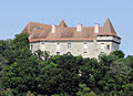
Goudourville Castle


Web links
Commons : Goudourville - collection of images, videos and audio files
Individual evidence
- ↑ Goudourville on Cassini.ehess.fr (French) Retrieved on 21 May 2018th