
Monesties
| Monesties | ||
|---|---|---|
.svg)
|
|
|
| region | Occitania | |
| Department | Camouflage | |
| Arrondissement | Albi | |
| Canton | Carmaux-2 Vallée du Cérou | |
| Community association | Carmausine Ségala | |
| Coordinates | 44 ° 4 ′ N , 2 ° 6 ′ E | |
| height | 190–437 m | |
| surface | 26.83 km 2 | |
| Residents | 1,367 (January 1, 2017) | |
| Population density | 51 inhabitants / km 2 | |
| Post Code | 81640 | |
| INSEE code | 81170 | |
| Website | www.monesties.com | |
.JPG) Candèze bridge in Monestiés |
||

Monestiés is a French commune in the department of Tarn in the region Occitania . Administratively it is assigned to the arrondissement of Albi and it is part of the canton of Carmaux-2 Vallée du Cérou (until 2015: canton of Monestiés ).
The village, which lies on a side route of the Camino de Santiago , has been classified as one of the Plus beaux villages de France ( Most Beautiful Villages in France ) since 2001 .
geography
The place with 1367 inhabitants (as of January 1, 2017) is located on the right bank of the Cérou around 20 kilometers north of Albi . It used to be the capital of the Cérou Valley and in the Middle Ages it was the most heavily fortified town on the right bank of the Tarn .
In fact, the medieval city was originally surrounded by a wall and a moat. The trenches were later filled in and a kennel was built in their place , which today serves as a walkway. The old houses stand in a circle around the Saint-Pierre church in a bend in the river.
history
In the first half of the 10th century , the West Frankish King Ludwig IV Déodat, abbot of the collegiate monastery Saint-Salvy von Albi, enfeoffed the Monasterio (also Monesterio ) estate , which at that time consisted of a sanctuary and a few outbuildings. The place name is derived from the Latin monastery ('monastery').
The settlement of the area goes back much further. 600 meters from the village center, at the confluence of the Ceret in the Cérou, traces of a Celtic oppidum from the late Iron Age have been found. A few centuries later, the inhabitants left the hills to settle along the Roman road that connected Rodez with Toulouse .
At the end of the Albigensian Crusade , Monestiés went to the bishops of Albi as a fief in 1229 . A co-seigneur was responsible for the military protection. This agreement was confirmed in 1282 by the French King Philip the Fair . In contrast to the bastides widespread in the region , the place developed concentrically around its church. To accommodate the pilgrims, a hostel was built outside the city walls in the 13th century.
The regional economic boom in the 18th century brought the village forward. Fonts name up to 23 resident dealers and 13 markets per year for this period. The population lived mainly from the processing of hemp fibers into fabrics and from the trade in donkeys . At that time the trenches were filled in and the city walls torn down so that the village could expand further. In the second half of the 19th century, cotton imported from the colonies displaced hemp weaving and Monestiés fell into the shadow of Carmaux , where large coal deposits were discovered.
coat of arms
Blazon : In red, a silver, black-walled tower flanked by two stars of the same color; Above that, two diagonally crossed silver keys, angled by a sun (heraldic right) and a crescent moon (heraldic left) of the same color.
Population development
The highest population figure was reached around 1865 with around 1,600 inhabitants.
| year | 1962 | 1968 | 1975 | 1982 | 1990 | 1999 | 2009 |
|---|---|---|---|---|---|---|---|
| Residents | 1,146 | 1,234 | 1,222 | 1,304 | 1,361 | 1,362 | 1,342 |
Attractions
- Peterskirche Église Saint-Pierre was rebuilt in 1550 in a Mediterranean Gothic style on the foundations of a Romanesque church that was destroyed in the run-up to the Huguenot Wars . It is made up of five parts and has three bays and five side chapels between the buttresses. The hired bell tower is flanked by a round defense tower and decorated with a bell that was cast in 1559. The building has been a French cultural monument since 1979 .
- The museum Musée Bajén-Vega in the center of the village is housed in a former manor house, which also serves as a tourist office. The exhibition shows pictures by some Spanish painters (including Francisco Bajén and his wife Martine Vega) who fled the Franco regime in 1939 .
- The pilgrim chapel Chapelle Saint-Jacques (also called Chapelle de l'Hôpital ) houses a multi-part stone sculpture of the Entombment of Christ , which was created in the 15th century for the bishops of Albi and before 1774 (like the choir stalls ) adorned the castle chapel Château de Combefa . This episcopal castle was south of Monestiés and is now destroyed.

Town hall ( Mairie ), behind it Saint-Pierre church

Entombment of Christ by Combefa
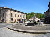
Village square with the Le Griffoul fountain (17th century)


Web links
Individual evidence
- ↑ Monestiés on Les plus Beaux Villages de France (French)
- ↑ Aerial photo of Monestiés on virtualtourist.com
- ^ Ernest Nègre : Les noms de lieux du Tarn . D'Artrey, Paris 1972, p. 93.
- ↑ Clément Compayré: Études historiques et documents inédits sur l'Albigeois, le Castrais, et l'ancien diocèse de Lavaur . Imprimerie de Maurice Papailhiau, Albi 1841, p. 320 ff.
- ^ Victor-Adolphe Malte-Brun: La France illustrée. Geography, history, administration and statistics . Gustave Barba, Paris 1865, p. 78.
- ↑ Entry no. PA00099759 in the Base Mérimée of the French Ministry of Culture (French)
- ↑ a b Laurence Michel: Midi Toulousain: Des Pyrénées à l'Aubrac . Michelin, 2010, p. 206.