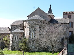
Ambialet
| Ambialet | ||
|---|---|---|

|
|
|
| region | Occitania | |
| Department | Camouflage | |
| Arrondissement | Albi | |
| Canton | Le Haut Dadou | |
| Community association | Monts d'Alban and Villefranchois | |
| Coordinates | 43 ° 54 ' N , 2 ° 20' E | |
| height | 183-526 m | |
| surface | 30.04 km 2 | |
| Residents | 459 (January 1, 2017) | |
| Population density | 15 inhabitants / km 2 | |
| Post Code | 81430 | |
| INSEE code | 81010 | |
| Website | http://www.ambialet.fr/ | |
 City Hall (Mairie) of Ambialet |
||
Ambialet ( identical in Occitan ) is a French commune with 459 inhabitants (as of January 1, 2017) in the Tarn department in the Occitania region (before 2016: Midi-Pyrénées ). Cambon belongs to the arrondissement of Albi and the canton of Le Haut Dadou (until 2015: canton of Villefranche-d'Albigeois ). The inhabitants are called Ambialetois .
location
Ambialet is about 18 kilometers east of Albi am Tarn , which borders the municipality in the north. Ambialet is surrounded by the neighboring communities of Saint-Cirque and Courris in the north, Assac in the north-east, Saint-André in the east, Le Fraysse in the south and south-east, Villefranche-d'Albigeois in the west and south-west and Sérénac in the north-west.
Population development
| year | 1962 | 1968 | 1975 | 1982 | 1990 | 1999 | 2006 | 2013 |
| Residents | 457 | 470 | 444 | 405 | 386 | 381 | 439 | 455 |
| Source: Cassini and INSEE | ||||||||
Attractions
- Notre-Dame-de-la-Chapelle church from the 11th century
- Saint-Gilles church from the 13th century
- Priory, Monument historique
- Ambialet Castle
- Le Colombié castle, partially destroyed in the 19th century
Web links
Commons : Ambialet - collection of images, videos and audio files

