
Cornus (Aveyron)
| Cornus | ||
|---|---|---|
.svg)
|
|
|
| region | Occitania | |
| Department | Aveyron | |
| Arrondissement | Millau | |
| Canton | Causses-Rougiers | |
| Community association | Larzac et Vallées | |
| Coordinates | 43 ° 54 ' N , 3 ° 11' E | |
| height | 496-887 m | |
| surface | 92.74 km 2 | |
| Residents | 524 (January 1, 2017) | |
| Population density | 6 inhabitants / km 2 | |
| Post Code | 12540 | |
| INSEE code | 12077 | |
| Website | http://www.cornus-aveyron.fr/ | |
 Town hall (Mairie) by Cornus |
||

Cornus (the same name in Occitan ) is a place and a municipality in the south of France with 524 inhabitants (as of January 1, 2017) in the Aveyron department in the Occitania region (previously Midi-Pyrénées ). Belmont-sur-Rance belongs to the Arrondissement of Millau and the canton of Causses-Rougiers (until 2015: canton of Cornus ). The inhabitants are called Cornusols .
location
Cornus is located about 22 kilometers south-southeast of Millau in the southwest of the historic Rouergue province . Cornus is surrounded by the neighboring communities of Sainte-Eulalie-de-Cernon in the north and north-west, La Couvertoirade in the east and north-east, Les Rives in the east and south-east, Romiguières in the south, Le Clapier in the south and south-west, Fondamente in the west and south-west and Saint -Beaulize in the west.
The A75 autoroute runs through the northeast of the municipality .
Population development
| year | 1962 | 1968 | 1975 | 1982 | 1990 | 1999 | 2006 | 2013 |
| Residents | 540 | 513 | 510 | 434 | 345 | 364 | 493 | 505 |
| Source: Cassini and INSEE | ||||||||
Attractions
- Dolmen
- Burial cave
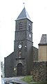
- 19th century Church of Cornus
- Canals Church
- Church of La Bastide-des-Fonts
- protestant church
- Sorgues Castle from the 15th century
- Remains of the tower of Aiguillon
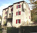
- Canals mansion

Church of Cornus
Canals Church
Sorgues Castle

Canals mansion
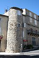
Aiguillon Tower


