
Fayet (Aveyron)
|
Fayet Faiet |
||
|---|---|---|
|
||
| region | Occitania | |
| Department | Aveyron | |
| Arrondissement | Millau | |
| Canton | Causses-Rougiers | |
| Community association | Monts, Rance and Rougier | |
| Coordinates | 43 ° 48 ' N , 2 ° 57' E | |
| height | 407-761 m | |
| surface | 15.87 km 2 | |
| Residents | 257 (January 1, 2017) | |
| Population density | 16 inhabitants / km 2 | |
| Post Code | 12360 | |
| INSEE code | 12099 | |
_mairie.JPG) Town Hall (Mairie) of Fayet |
||

Fayet ( Occitan : Faiet ) is a place and a municipality in the south of France with 257 inhabitants (as of January 1, 2017) in the Aveyron department in the Occitania region (previously Midi-Pyrénées ). Fayet belongs to the Millau arrondissement and the Causses-Rougiers canton (until 2015: Camarès canton ). The inhabitants are called Fayetois .
location
Fayet is located about 46 kilometers east-southeast of Albi on the Dourdou de Camarès in the southwest of the historic Rouergue province . Fayet is surrounded by the neighboring communities of Sylvanès in the north, Montagnol in the east and northeast, Tauriac-de-Camarès in the southeast, Brusque in the south and Camarès in the west.
Population development
| year | 1962 | 1968 | 1975 | 1982 | 1990 | 1999 | 2006 | 2013 |
| Residents | 460 | 408 | 305 | 280 | 253 | 271 | 285 | 293 |
| Source: Cassini and INSEE | ||||||||
Attractions
- Saint Laurent Church
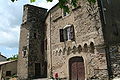
- Fayet Castle from the 16th century, monument historique since 1954
- La Roque castle from the 16th century, monument historique since 2004
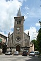
Saint Laurent Church

Fayet Castle
La Roque Castle
_facade_eglise.jpg)


Web links
Commons : Fayet - collection of images, videos and audio files