
Saint-Laurent-de-Lévézou
|
Saint-Laurent-de-Lévézou Sent Laurenç de Leveson |
||
|---|---|---|
|
||
| region | Occitania | |
| Department | Aveyron | |
| Arrondissement | Millau | |
| Canton | Raspes et Lévezou | |
| Community association | Lévézou Pareloup | |
| Coordinates | 44 ° 13 ' N , 2 ° 58' E | |
| height | 614-1,121 m | |
| surface | 23.33 km 2 | |
| Residents | 153 (January 1, 2017) | |
| Population density | 7 inhabitants / km 2 | |
| Post Code | 12620 | |
| INSEE code | 12236 | |
 Mairie Saint-Laurent-de-Lévézou |
||

Saint-Laurent-de-Lévézou ( Occitan : Sent laurenc de Leveson ) is a French commune of the department of Aveyron in the region Occitania (before 2016: Midi-Pyrénées ) with 153 inhabitants (as of January 1 2017). Administratively, it is assigned to the canton of Raspes et Lévezou (until 2015: canton of Vézins-de-Lévézou ) and the arrondissement of Millau . The inhabitants are called Saint-Laurentais .
geography
Saint-Laurent-de-Lévézou is located about 15 kilometers northwest of Millau and about 34 kilometers east-southeast of Rodez in one of the southern foothills of the Massif Central in a wooded region. The municipality is part of the Grands Causses Regional Nature Park . Saint-Laurent-de-Lévézou is surrounded by the neighboring communities of Vézins-de-Lévézou in the north and west, Saint-Léons in the east, Saint-Beauzély in the south and south-east and Curan in the west and south-west.
Population development
| year | 1962 | 1968 | 1975 | 1982 | 1990 | 1999 | 2006 | 2013 |
|---|---|---|---|---|---|---|---|---|
| Residents | 230 | 198 | 166 | 157 | 124 | 152 | 155 | 157 |
| Source: Cassini and INSEE | ||||||||
Attractions
- Saint Laurent Church
- Saints-Abdon-et-Sennen church in the Mauriac district
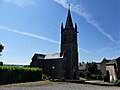
Saint Laurent Church

Saints-Abdon-et-Sennen church
.jpg)
.jpg)