
Saint-Jean-et-Saint-Paul
|
Saint-Jean-et-Saint-Paul Sent Joan e Sent Paul |
||
|---|---|---|

|
|
|
| region | Occitania | |
| Department | Aveyron | |
| Arrondissement | Millau | |
| Canton | Causses-Rougiers | |
| Community association | Larzac et Vallées | |
| Coordinates | 43 ° 56 ' N , 3 ° 0' E | |
| height | 432-825 m | |
| surface | 37.91 km 2 | |
| Residents | 278 (January 1, 2017) | |
| Population density | 7 inhabitants / km 2 | |
| Post Code | 12250 | |
| INSEE code | 12232 | |

Saint-Jean-et-Saint-Paul ( Occitan : Sent Joan e Sent Paul ) is a southern French municipality with 278 inhabitants (as of January 1, 2017) in the Aveyron department in the Occitania region (previously Midi-Pyrénées ). Belmont-sur-Rance belongs to the Arrondissement of Millau and the canton of Causses-Rougiers (until 2015: canton of Cornus ). The inhabitants are called Jean-Pauliens .
The municipality consists of the localities of Saint-Jean-d'Alcas and Saint-Paul-des-Fonts with several other hamlets.
location
Saint-Jean-et-Saint-Paul is located about 19 kilometers south-southwest of Millau in the southwest of the historic Rouergue province . Saint-Jean-et-Saint-Paul is surrounded by the neighboring communities Roquefort-sur-Soulzon and Tournemire in the north, Viala-du-Pas-de-Jaux in the north and northeast, Sainte-Eulalie-de-Cernon in the east and northeast, Saint-Beaulize in the east and south-east, Marnhagues-et-Latour and Saint-Félix-de-Sorgues in the south, Versols-et-Lapeyre in the south-west and Saint-Affrique in the west and north-west.
Population development
| year | 1962 | 1968 | 1975 | 1982 | 1990 | 1999 | 2006 | 2013 |
| Residents | 314 | 303 | 275 | 242 | 208 | 218 | 257 | 268 |
| Source: Cassini and INSEE | ||||||||
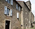
Attractions
- Les Treilles cave
- Saint-Jean church
- La Vialette Castle, Monument historique since 1984
- Fortification (1440–1445) of Saint-Jean-d'Alcas
Saint-Jean church

Fortification of Saint-Jean-d'Alcas

