
Keikyū main line
| Keikyū main line | |||||||||||||||||||||||||||||||||||||||||||||||||||||||||||||||||||||||||||||||||||||||||||||||||||||||||||||||||||||||||||||||||||||||||||||||||||||||||||||||||||||||||||||||||||||||||||||||||||||||||||||||||||||||||||||||||||||||||||||||||||||||||||||||||||||||||||||||||||||||||||||||||||||||||||||||||||||||||||||||||||||||||||||||||||||||||||||||||||||||||||||||||||||||||||||||||||||||||||||||||||||||||||||||||||||||||||||||||||||||||||||||||||||||||||||||||||||||||||||||||||||||||||||||||||||||||||||||||||||||||||||||||||||||||||||||||||||||||||||||||||||||||||||||||||||||||
|---|---|---|---|---|---|---|---|---|---|---|---|---|---|---|---|---|---|---|---|---|---|---|---|---|---|---|---|---|---|---|---|---|---|---|---|---|---|---|---|---|---|---|---|---|---|---|---|---|---|---|---|---|---|---|---|---|---|---|---|---|---|---|---|---|---|---|---|---|---|---|---|---|---|---|---|---|---|---|---|---|---|---|---|---|---|---|---|---|---|---|---|---|---|---|---|---|---|---|---|---|---|---|---|---|---|---|---|---|---|---|---|---|---|---|---|---|---|---|---|---|---|---|---|---|---|---|---|---|---|---|---|---|---|---|---|---|---|---|---|---|---|---|---|---|---|---|---|---|---|---|---|---|---|---|---|---|---|---|---|---|---|---|---|---|---|---|---|---|---|---|---|---|---|---|---|---|---|---|---|---|---|---|---|---|---|---|---|---|---|---|---|---|---|---|---|---|---|---|---|---|---|---|---|---|---|---|---|---|---|---|---|---|---|---|---|---|---|---|---|---|---|---|---|---|---|---|---|---|---|---|---|---|---|---|---|---|---|---|---|---|---|---|---|---|---|---|---|---|---|---|---|---|---|---|---|---|---|---|---|---|---|---|---|---|---|---|---|---|---|---|---|---|---|---|---|---|---|---|---|---|---|---|---|---|---|---|---|---|---|---|---|---|---|---|---|---|---|---|---|---|---|---|---|---|---|---|---|---|---|---|---|---|---|---|---|---|---|---|---|---|---|---|---|---|---|---|---|---|---|---|---|---|---|---|---|---|---|---|---|---|---|---|---|---|---|---|---|---|---|---|---|---|---|---|---|---|---|---|---|---|---|---|---|---|---|---|---|---|---|---|---|---|---|---|---|---|---|---|---|---|---|---|---|---|---|---|---|---|---|---|---|---|---|---|---|---|---|---|---|---|---|---|---|---|---|---|---|---|---|---|---|---|---|---|---|---|---|---|---|---|---|---|---|---|---|---|---|---|---|---|---|---|---|---|---|---|---|---|---|---|---|---|---|---|---|---|---|---|---|---|---|---|---|---|---|---|---|---|---|---|---|---|---|---|---|---|---|---|---|---|---|---|---|---|---|---|---|---|---|---|---|---|---|---|---|---|---|---|---|---|---|---|---|---|---|---|---|---|---|---|---|---|---|---|---|---|---|---|---|---|---|---|---|---|---|---|---|---|---|---|---|---|---|---|---|---|---|---|---|---|---|---|---|---|---|---|---|---|---|---|---|---|---|---|---|---|---|---|---|---|---|---|---|---|---|---|---|---|---|---|---|---|---|---|---|---|---|---|---|---|---|---|---|---|---|---|---|---|---|---|---|---|---|---|---|
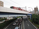
 Class N1000 multiple unit in Kanazawa
| |||||||||||||||||||||||||||||||||||||||||||||||||||||||||||||||||||||||||||||||||||||||||||||||||||||||||||||||||||||||||||||||||||||||||||||||||||||||||||||||||||||||||||||||||||||||||||||||||||||||||||||||||||||||||||||||||||||||||||||||||||||||||||||||||||||||||||||||||||||||||||||||||||||||||||||||||||||||||||||||||||||||||||||||||||||||||||||||||||||||||||||||||||||||||||||||||||||||||||||||||||||||||||||||||||||||||||||||||||||||||||||||||||||||||||||||||||||||||||||||||||||||||||||||||||||||||||||||||||||||||||||||||||||||||||||||||||||||||||||||||||||||||||||||||||||||||
| Route length: | 56.7 km | ||||||||||||||||||||||||||||||||||||||||||||||||||||||||||||||||||||||||||||||||||||||||||||||||||||||||||||||||||||||||||||||||||||||||||||||||||||||||||||||||||||||||||||||||||||||||||||||||||||||||||||||||||||||||||||||||||||||||||||||||||||||||||||||||||||||||||||||||||||||||||||||||||||||||||||||||||||||||||||||||||||||||||||||||||||||||||||||||||||||||||||||||||||||||||||||||||||||||||||||||||||||||||||||||||||||||||||||||||||||||||||||||||||||||||||||||||||||||||||||||||||||||||||||||||||||||||||||||||||||||||||||||||||||||||||||||||||||||||||||||||||||||||||||||||||||||
| Gauge : | 1435 mm ( standard gauge ) | ||||||||||||||||||||||||||||||||||||||||||||||||||||||||||||||||||||||||||||||||||||||||||||||||||||||||||||||||||||||||||||||||||||||||||||||||||||||||||||||||||||||||||||||||||||||||||||||||||||||||||||||||||||||||||||||||||||||||||||||||||||||||||||||||||||||||||||||||||||||||||||||||||||||||||||||||||||||||||||||||||||||||||||||||||||||||||||||||||||||||||||||||||||||||||||||||||||||||||||||||||||||||||||||||||||||||||||||||||||||||||||||||||||||||||||||||||||||||||||||||||||||||||||||||||||||||||||||||||||||||||||||||||||||||||||||||||||||||||||||||||||||||||||||||||||||||
| Power system : | 1500 V = | ||||||||||||||||||||||||||||||||||||||||||||||||||||||||||||||||||||||||||||||||||||||||||||||||||||||||||||||||||||||||||||||||||||||||||||||||||||||||||||||||||||||||||||||||||||||||||||||||||||||||||||||||||||||||||||||||||||||||||||||||||||||||||||||||||||||||||||||||||||||||||||||||||||||||||||||||||||||||||||||||||||||||||||||||||||||||||||||||||||||||||||||||||||||||||||||||||||||||||||||||||||||||||||||||||||||||||||||||||||||||||||||||||||||||||||||||||||||||||||||||||||||||||||||||||||||||||||||||||||||||||||||||||||||||||||||||||||||||||||||||||||||||||||||||||||||||
| Top speed: | 120 km / h | ||||||||||||||||||||||||||||||||||||||||||||||||||||||||||||||||||||||||||||||||||||||||||||||||||||||||||||||||||||||||||||||||||||||||||||||||||||||||||||||||||||||||||||||||||||||||||||||||||||||||||||||||||||||||||||||||||||||||||||||||||||||||||||||||||||||||||||||||||||||||||||||||||||||||||||||||||||||||||||||||||||||||||||||||||||||||||||||||||||||||||||||||||||||||||||||||||||||||||||||||||||||||||||||||||||||||||||||||||||||||||||||||||||||||||||||||||||||||||||||||||||||||||||||||||||||||||||||||||||||||||||||||||||||||||||||||||||||||||||||||||||||||||||||||||||||||
| Dual track : | whole route | ||||||||||||||||||||||||||||||||||||||||||||||||||||||||||||||||||||||||||||||||||||||||||||||||||||||||||||||||||||||||||||||||||||||||||||||||||||||||||||||||||||||||||||||||||||||||||||||||||||||||||||||||||||||||||||||||||||||||||||||||||||||||||||||||||||||||||||||||||||||||||||||||||||||||||||||||||||||||||||||||||||||||||||||||||||||||||||||||||||||||||||||||||||||||||||||||||||||||||||||||||||||||||||||||||||||||||||||||||||||||||||||||||||||||||||||||||||||||||||||||||||||||||||||||||||||||||||||||||||||||||||||||||||||||||||||||||||||||||||||||||||||||||||||||||||||||
| Society: | Keikyu | ||||||||||||||||||||||||||||||||||||||||||||||||||||||||||||||||||||||||||||||||||||||||||||||||||||||||||||||||||||||||||||||||||||||||||||||||||||||||||||||||||||||||||||||||||||||||||||||||||||||||||||||||||||||||||||||||||||||||||||||||||||||||||||||||||||||||||||||||||||||||||||||||||||||||||||||||||||||||||||||||||||||||||||||||||||||||||||||||||||||||||||||||||||||||||||||||||||||||||||||||||||||||||||||||||||||||||||||||||||||||||||||||||||||||||||||||||||||||||||||||||||||||||||||||||||||||||||||||||||||||||||||||||||||||||||||||||||||||||||||||||||||||||||||||||||||||
|
|||||||||||||||||||||||||||||||||||||||||||||||||||||||||||||||||||||||||||||||||||||||||||||||||||||||||||||||||||||||||||||||||||||||||||||||||||||||||||||||||||||||||||||||||||||||||||||||||||||||||||||||||||||||||||||||||||||||||||||||||||||||||||||||||||||||||||||||||||||||||||||||||||||||||||||||||||||||||||||||||||||||||||||||||||||||||||||||||||||||||||||||||||||||||||||||||||||||||||||||||||||||||||||||||||||||||||||||||||||||||||||||||||||||||||||||||||||||||||||||||||||||||||||||||||||||||||||||||||||||||||||||||||||||||||||||||||||||||||||||||||||||||||||||||||||||||
The Keikyū main line ( 京 急 本 線 , Keikyū-honsen ) is a railway line on the Japanese island of Honshū , which is operated by the Keikyū railway company . It connects the Minato district in Tokyo with the cities of Kanagawa , Yokohama and Yokosuka in the Kanagawa Prefecture to the south of it . It runs from the Kanto plain along the coast of Tokyo Bay to the Miura Peninsula . Developed from a short interurban tram , it developed within a few decades into the busy trunk line of the Keikyū, which is connected with several branches.
Route description
The 56.7 km long, double-track line is electrified with 1500 V DC and serves 50 train stations. It is laid in the standard gauge of 1435 mm, which - apart from the Shinkansen high-speed network - rarely occurs in Japan (the Cape gauge of 1067 mm is common). This gives the Keikyū trains a certain competitive advantage over other railway companies in the corridor between the megacities of Tokyo and Yokohama , as higher speeds are usually possible. On the section mentioned, the trains travel at up to 120 km / h, otherwise at up to 110 km / h.
The northern starting point of the Keikyū main line is the Sengakuji underground station in Tokyo's Minato district , where it branches off the Asakusa line of the Tokyo subway . In the vicinity of the Takanawa Gateway train station , it comes to the surface via a 38 per mille steep ramp (33 per mille in the opposite direction). Usually in Sengakuji fast and express trains in and out towards the city center by bound . Local trains with stops at all stations start and end in the vast majority of cases in the adjacent Shinagawa station . Here the Keikyū has three tracks in the westernmost part of the station. After bridging the Tōkaidō main line and the Tōkaidō Shinkansen , Kitashinagawa is reached, from where an approximately nine kilometer long viaduct extends uninterrupted to Rokugōdote. In between, the Keikyū airport line to Haneda Airport branches off at Keikyū Kamata station .
The Tama River forms the border with Kanagawa Prefecture and Kawasaki City . From here on, viaducts, railway embankments and ground-level sections alternate. The Keikyū Daishi line , which branches off in Keikyū Kawasaki, is not directly connected to the main line, but only via operating tracks. Hatchōnawate is a tower train station where the Keikyū main line passes under the Nambu line . Shortly thereafter, the city limits to Yokohama and the bridge over the Tsurumi follow . Over a distance of more than six kilometers, the Keikyū main line runs largely parallel to the Tōkaidō main line to Yokohama station , a major railway junction .
West of downtown Yokohama and through a range of hills, the route reaches the Taloka valley and follows the river on a winding route . In Kamiōoka there is a transfer option to the Yokohama subway . The route then approaches the coast again. The Keikyū Zushi line branches off in Kanazawa-hakkei , and it is also possible to change to the Kanazawa Seaside Line here. From here the terrain becomes increasingly mountainous and the route runs through a number of tunnels. It crosses the Yokosuka line twice . After the branch of the Keikyū Kurihama Line in Horinouichi , it ends in Uraga at the end of a narrow branch of Tokyo Bay .
Trains

The supply of trains on the Keikyū main line is very dense. During the day, for example, 18 to 21 trains per hour run on the Shinagawa - Yokohama section , and up to 24 trains during rush hour . With the exception of the Daishi line, there are free connections to all other lines in the Keikyū route network. The northern starting point of about half of all trains is Shinagawa (mostly local trains). The others will be tied through to the Asakusa line of the Tokyo subway in the adjoining Sengakuji station ; they run to Oshiage or on to Narita Airport and Shibayama-Chiyoda .
There are six different types of train, with express and express trains omitting a different number of intermediate stations:
■ Eapōto Kaitoku ( エアポート快特 , Engl. Airport Limited Express )
This airport Zubringerzug is the fastest connection between Haneda Airport and the city center. It runs from the two airport train stations without stopping to Shinagawa. Then it is tied through to the Asakusa line and further to the Keisei main line . In this way, it creates a direct connection to Narita Airport .
■ Eapōto Kyūkō ( エ ア ポ ー ト 急 行 , English Airport Express )
Airport shuttle train with two different routes. On the one hand from Haneda airport via Shinjuku to the Asakusa line, on the other hand from Haneda airport via Yokohama and Kanazawa-hakkei to Zushi-Hayama on the Keikyū Zushi line . He stops at several intermediate stations on the way.
■ Tokkyū ( 特急 , Limited Express )
Coming from the Asakusa line, travels via Shinagawa, Yokohama and Kanazawa-hakkei to Uraga and back. Only offered during rush hour and stops at most stations on all express trains.
■ Kaitoku ( 快 特 , Limited Express )
standard express train at all times of the day. Comes from the Asakusa Line via Shinagawa, Yokohama, Kanazawa-hakkei and Horinouchi to Misakiguchi on the Keikyū Kurihama Line .
■ Morning Wing ( モーニング·ウィング号 and Evening Wing ( イブニング·ウィング号 )
The Wing-fast trains meet the Home liners with other railway companies and offer exclusively reserved seats, for which a supplement is payable. In the morning pervert the Morning Wing from Miurakaigan to the Keikyū Kurihama Line to Tokyo, and in the evening the Evening Wings return to Misakiguchi, not stopping at any train station between Kamiōoka and Shinagawa (including Yokohama).
■ Futsū ( 普通 , English local )
local trains stopping at all stations. Usually not tied through to the subway.
photos

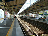
Shinagawa Railway Station
Suzugamori Viaduct

Bridge over the Tama
Keikyu Kawasaki Station

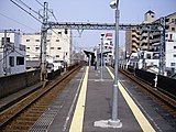
Yokohama Railway Station
Koganecho station
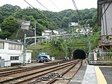
Tunnel at Hemi station

A train arrives at Uraga station


history
Starts as an interurban tram
The Keihin Kyūkō Dentetsu ("Electric Keihin Express Railway", Keikyū for short ), founded in 1898, is the third electric suburban railway in Japan and the first in the capital region of Kantō . She opened on February 1, 1901, the first section of what would later become the main line from Ōmorikaigan to Rokugōbashi , where there was a connection to the Daishi line that had been opened two years earlier . There was also a short branch line to Ōmori-teishaba-mae, a stop next to Ōmori station on the Tōkaidō main line . The Keikyū had built the lines in standard gauge (1435 mm), which was very unusual in Japan at that time; the contact line voltage was 600 V. On September 1, 1902, a southern extension from Rokugōbashi to Keikyū Kawasaki followed .
When the opportunity arose, one by binding to the tram Tokyo set up the company, its own routes decided in the usual with Japanese trams "Scottish track" of 1372 mm switch tracks . This happened on March 1, 1904. A little more than two months later, on May 8, the Keikyū extended the main line from Ōmorikaigan north to Kitashinagawa, where the transition to the tram network was. With the opening of the section between Keikyū Kawasaki and Kanagawa on December 24, 1905, the Keikyū main line now established a continuous connection between the then outskirts of Tokyo and Yokohama .
Since the agreement on connecting trains had not been renewed on August 11, 1924, the Keikyū moved its Tokyo terminus on March 11, 1925 a few hundred meters north to the Takanawa stop, which was located on the forecourt opposite the main entrance of Shinagawa station. At the southern end, the Keikyū main line was extended on June 22, 1929 from Kanagawa to Yokohama Station , the trains initially stopped at a makeshift platform; the definitive platform was available from February 5, 1930. On April 1, 1933, the Keikyū gave up the northern terminus of Takanawa again, instead all trains now ran from Shinagawa station, with the Keikyū main line finally losing its previous character as an interurban tram .
Expansion to the Miura Peninsula

Another railway company, the Shōnan Denki Tetsudō , was founded on December 27, 1925 and had begun building a standard-gauge line from Yokohama to the Miura Peninsula . The Keikyū was financially involved and provided part of the management. On April 1, 1930, the section from Koganecho to Uraga was opened . The missing section between Yokohama and Koganechō was added on December 26, 1931. Because of different gauges, a change had to be made at Yokohama station. The Keikyū wanted to have connections beyond Yokohama without having to change trains, but according to the local railway law at the time, standard gauge tracks were not allowed to be switched to the Scottish gauge (1372 mm). Therefore, in September 1931 the decision was made to convert the Keikyū main line back to standard gauge (1435 mm) instead - as it had already existed from 1901 to 1904.
The gauging was completed on April 1, 1933, but in Koganechō there was still an operational separation of the contact wire voltage. North of it it was 600 V, south of it 1500 V. On December 25, 1936, it was lowered to 600 V on the Koganechō– Kamiōoka section so that express trains from Shinagawa could run there. On March 8, 1937, the Keikyū closed the short branch line to Ōmori-teishaba-mae. After the outbreak of the Pacific War , the Japanese government sought to improve the efficiency of smaller private transport companies. To this end, in 1938 she passed the “Law for the Coordination of Land Transport Companies”, which enabled her to arrange mergers into larger units , especially in the metropolitan areas . On this basis, the Keikyū took over the Shōnan Denki Tetsudō on November 1, 1941 and integrated the company completely.
Taking advantage of the same law, Keita Gotō sought the unification of all private railway companies in the southwest of the Tokyo metropolitan area under the umbrella of the Tōkyū Dentetsu, which he presided over . So the Keikyū went on May 1, 1942 together with the Odakyū Dentetsu and the Tōkyū Dentetsu in the Daitōkyū conglomerate, on May 31, 1944 also the Keiō Dentetsu . The new owner streamlined operations by closing several train stations. It increased the overhead line voltage between Yokohama and Kamiōoka to 1500 V on December 22, 1945, and on December 25, 1947 also between Shinagawa and Yokohama. Thus the entire Shinagawa – Uraga route now had uniform parameters. Two years after the end of the war, the shareholders decided on November 26, 1947 at an extraordinary meeting to dissolve the financially troubled Daitōkyū conglomerate through spin-offs . From June 1, 1948, Keikyū was again an independent company.
Modernizations

The maximum permissible speed on the Keikyū main line had previously been 80 km / h, but could only actually be reached in a few places due to the war damage. Through modifications and extensions in the following years, it gradually decreased: In July 1953 to 90 km / h, in September 1958 to 100 km / h and in March 1967 to 105 km / h. In this way, the travel time of the express trains between Shinagawa and Yokohama was successively reduced from 47 to 21 minutes. On June 21, 1968, the Keikyū extended its main line from Shinagawa to Sengakuji . Thanks to this expansion, it was now possible to connect Keikyū trains to the Asakusa line of the Toei subway and vice versa. Construction work began later to relocate the ground-level route between Kitashinagawa and Aomono-yokochō on a viaduct, thus lifting several level crossings. The viaduct was put into operation on August 27, 1975, initially for the south-facing track, and on October 15, 1976 for the north-facing track as well.
Keikyū increased the maximum speed for express trains between Shinagawa and Yokohama on February 21, 1995 to the currently valid 120 km / h, whereby the journey time could be reduced to just under 16 minutes. The speed limit south of Yokohama has been 110 km / h since then. This was made possible by further line extensions. The viaduct reached from December 2, 1990 beyond Aomono-yokochō to Ōmorikaigan, from December 21, 2012 to Rokugōdote. In addition, on May 12, 1996, a second viaduct was built between Kamiōoka and Byōbugaura.
List of train stations
AE = Airport Express; AL = Airport Limited Express; To = Tokkyū (Limited Express); Ka = Kaitoku (Limited Express); Wi = Morning Wing / Evening Wing
| Surname | km | AE | AE | AL | To | Ka | Wi | Connecting lines | location | place | prefecture | |
|---|---|---|---|---|---|---|---|---|---|---|---|---|
| A07 | Sengakuji ( 泉 岳 寺 ) | −1.2 | ● | ● | ● | ● | (●) | Tokyo Subway : Asakusa Line | Coord. | Minato , Tokyo | Tokyo | |
| KK01 | Shinagawa ( 品 川 ) | 0.0 | ● | ● | ● | ● | ● |
Tōkaidō Shinkansen Keihin Tōhoku Line Tōkaidō Main Line Yamanote Line Yokosuka Line |
Coord. | |||
| KK02 | Kitashinagawa ( 北 品 川 ) | 0.7 | ǀ | ǀ | ǀ | ǀ | ǀ | Coord. | Shinagawa , Tokyo | |||
| KK03 | Shimbamba ( 新 馬 場 ) | 1.4 | ǀ | ǀ | ǀ | ǀ | ǀ | Coord. | ||||
| KK04 | Aomono-yokochō ( 青 物 横 丁 ) | 2.2 | ● | ǀ | ● | ǀ | ǀ | Coord. | ||||
| KK05 | Samezu ( 鮫 洲 ) | 2.7 | ǀ | ǀ | ǀ | ǀ | ǀ | Coord. | ||||
| KK06 | Tachiaigawa ( 立 会 川 ) | 3.5 | ● | ǀ | ǀ | ǀ | ǀ | Coord. | ||||
| KK07 | Ōmorikaigan ( 大 森海 岸 ) | 4.8 | ǀ | ǀ | ǀ | ǀ | ǀ | Coord. | ||||
| KK08 | Heiwajima ( 平和 島 ) | 5.7 | ● | ǀ | ● | ǀ | ǀ | Coord. | Ōta , Tokyo | |||
| KK09 | Ōmorimachi ( 大 森 町 ) | 6.5 | ǀ | ǀ | ǀ | ǀ | ǀ | Coord. | ||||
| KK10 | Umeyashiki ( 梅 屋 敷 ) | 7.2 | ǀ | ǀ | ǀ | ǀ | ǀ | Coord. | ||||
| KK11 | Keikyū Kamata ( 京 急 蒲 田 ) | 8.0 | ● | ● | ǀ | ● | ● | ǀ | Keikyu Airport Line | Coord. | ||
| KK18 | Zōshiki ( 雑 色 ) | 9.4 | ǀ | ǀ | ǀ | ǀ | Coord. | |||||
| KK19 | Rokugōdote ( 六 郷 土 手 ) | 10.6 | ǀ | ǀ | ǀ | ǀ | Coord. | |||||
| KK20 | Keikyū Kawasaki ( 京 急 川 崎 ) | 11.8 | ● | ● | ● | ǀ |
Keikyū Daishi Line at Kawasaki Station : Tōkaidō Main Line Keihin-Tōhoku Line Nambu Line |
Coord. | Kawasaki-ku , Kawasaki | Kanagawa | ||
| KK27 | Hatchōnawate ( 八 丁 畷 ) | 13.1 | ǀ | ǀ | ǀ | ǀ | Nambu line | Coord. | ||||
| KK28 | Tsurumi-Ichiba ( 鶴 見 市場 ) | 13.8 | ǀ | ǀ | ǀ | ǀ | Coord. | Tsurumi-ku , Yokohama | ||||
| KK29 | Keikyū Tsurumi ( 京 急 鶴 見 ) | 15.3 | ● | ǀ | ǀ | ǀ |
at Tsurumi station : Keihin-Tōhoku line Tsurumi line |
Coord. | ||||
| KK30 | Kagetsuen-mae ( 花 月 園 前 ) | 16.1 | ǀ | ǀ | ǀ | ǀ | Coord. | |||||
| KK31 | Namamugi ( 生 麦 ) | 16.9 | ǀ | ǀ | ǀ | ǀ | Coord. | |||||
| KK32 | Keikyū Shinkoyasu ( 京 急 新 子 安 ) | 18.3 | ǀ | ǀ | ǀ | ǀ |
at Shin-Koyasu Station: Keihin-Tōhoku Line |
Coord. | Kanagawa-ku , Yokohama | |||
| KK33 | Koyasu ( 子 安 ) | 19.3 | ǀ | ǀ | ǀ | ǀ | Coord. | |||||
| KK34 | Kanagawa Shimmachi ( 神奈川 新 町 ) | 20.0 | ● | ● | ǀ | ǀ | Coord. | |||||
| KK35 | Nakakido ( 仲 木 戸 ) | 20.5 | ● | ǀ | ǀ | ǀ | Coord. | |||||
| KK36 | Kanagawa ( 神奈川 ) | 21.5 | ǀ | ǀ | ǀ | ǀ | Coord. | |||||
| KK37 | Yokohama ( 横 浜 ) | 22.2 | ● | ● | ● | ǀ |
Tōkaidō Main Line Keihin-Tōhoku Line Negishi Line Yokosuka Line Sōtetsu Main Line Tōyoko Line Yokohama Subway : Blue Line Minatomirai Line |
Coord. | Nishi-ku , Yokohama | |||
| KK38 | Tobe ( 戸 部 ) | 23.4 | ǀ | ǀ | ǀ | ǀ | Coord. | |||||
| KK39 | Hinodechō ( 日 ノ 出 町 ) | 24.8 | ● | ǀ | ǀ | ǀ | Coord. | Naka-ku , Yokohama | ||||
| KK40 | Koganechō ( 黄金 町 ) | 25.6 | ǀ | ǀ | ǀ | ǀ | Coord. | Minami-ku , Yokohama | ||||
| KK41 | Minamiōta ( 南 太 田 ) | 26.5 | ǀ | ǀ | ǀ | ǀ | Coord. | |||||
| KK42 | Idogaya ( 井 土 ヶ 谷 ) | 27.7 | ● | ǀ | ǀ | ǀ | Coord. | |||||
| KK43 | Gumyōji ( 弘 明 寺 ) | 29.1 | ● | ǀ | ǀ | ǀ | Coord. | |||||
| KK44 | Kamiōoka ( 上 大 岡 ) | 30.8 | ● | ● | ● | ● |
Yokohama Subway: Blue Line |
Coord. | Kōnan-ku , Yokohama | |||
| KK45 | Byōbugaura ( 屏風 浦 ) | 33.0 | ǀ | ǀ | ǀ | ǀ | Coord. | Isogo-ku , Yokohama | ||||
| KK46 | Sugita ( 杉 田 ) | 34.3 | ● | ǀ | ǀ | ǀ | Coord. | |||||
| KK47 | Keikyū Tomioka ( 京 急 富 岡 ) | 36.7 | ǀ | ǀ | ǀ | ǀ | Coord. | Kanazawa-ku , Yokohama | ||||
| KK48 | Nōkendai ( 能見 台 ) | 37.4 | ● | ǀ | ǀ | ǀ | Coord. | |||||
| KK49 | Kanazawa-bunko ( 金 沢 文庫 ) | 39.5 | ● | ● | ● | ● | Coord. | |||||
| KK50 | Kanazawa-hakkei ( 金 沢 八景 ) | 40.9 | ● | ● | ● | (●) |
Keikyū Zushi Line Kanazawa Seaside Line |
Coord. | ||||
| KK54 | Oppama ( 追 浜 ) | 42.8 | ● | ǀ | ǀ | Coord. | Yokosuka | |||||
| KK55 | Keikyū Taura ( 京 急 田 浦 ) | 44.5 | ǀ | ǀ | ǀ | Coord. | ||||||
| KK56 | Anjinzuka ( 安 針 塚 ) | 47.1 | ǀ | ǀ | ǀ | Coord. | ||||||
| KK57 | Hemi ( 逸 見 ) | 48.1 | ǀ | ǀ | ǀ | Coord. | ||||||
| KK58 | Shioiri ( 汐 入 ) | 49.2 | ● | ǀ | ǀ | Coord. | ||||||
| KK59 | Yokosuka-chūō ( 横須賀 中央 ) | 49.9 | ● | ● | ● | Coord. | ||||||
| KK60 | Kenritsudaigaku ( 県 立 大学 ) | 51.1 | ǀ | ǀ | ǀ | Coord. | ||||||
| KK61 | Horinouchi ( 堀 ノ 内 ) | 52.3 | ● | ● | ● | Keikyū Kurihama lineage | Coord. | |||||
| KK62 | Keikyū Ōtsu ( 京 急 大 津 ) | 53.1 | ● | Coord. | ||||||||
| KK63 | Maborikaigan ( 馬 堀 海岸 ) | 54.2 | ● | Coord. | ||||||||
| KK64 | Uraga ( 浦 賀 ) | 55.5 | ● | Coord. | ||||||||
Web links
Individual evidence
- ↑ Mitsuo Takano (Ed.): 京 急 ダ イ ヤ の 歴 史. 2011, p. 50.
- ↑ Tetsudō Pikutoriaru, No. 656. Denkisha kenkyūkai, Chiyoda. July 1998, p. 104.
- ↑ Timetable from Shinagawa. (PDF, 2.85 MB) Keikyū , October 28, 2019, accessed August 30, 2020 (Japanese).
- ↑ a b c d e Masashi Nakamura: 週刊 私 鉄 全 駅 ・ 全 車 両 基地 No.10 京 浜 急 行 電 鉄 ① . Asahi Shimbun-sha, Osaka 2014, p. 29 .
- ↑ Kenta Miyata: 京 急電 鉄 明治 ・ 大 正 ・ 昭和 の 歴 史 と 沿線 . JTB Publishing, Tokyo 2015, ISBN 4-533-10675-7 , pp. 63-64 .
- ↑ Mitsuo Yoshimura: 京 浜 急 行 今昔 物語 . Tamagawa Shimbun-sha, Kawasaki 1995, p. 49-51 .
- ↑ Yoshimura: 京 浜 急 行 今昔 物語. P. 58.
- ↑ 小田急 五 十年 史 ”. 小田急 電 鉄 (1980 年). Shibusawa Shashi Database, accessed August 30, 2020 (Japanese).
- ↑ Takashi Dōtaira: 京 急 の ス ピ ー ド ア ッ プ と 2 灯 明 滅 信号 . In: Tetsudō to denki gijutsu . tape 8 , no. 4 . Nihon Tetsudō Denki Gijutsu Kyōkai, April 1997, ISSN 0915-9231 , p. 61-63 .
- ↑ 湘南 - 京 葉 地下 で 結 ぶ / 京 浜 急 行 ← → 都 営 地下 鉄 ← → 京 成 電 鉄 / 相互 乗 り 入 れ の 開通 式. In: Yomiuri Shinbun , June 20, 1968, p. 10.
- ↑ Ryōsuke Satō: 京 急 の 駅 今昔 ・ 昭和 の 面 影 . JTB Publishing, Tokyo 2006, ISBN 4-533-06175-3 , pp. 46 .
- ↑ Tetsudō Fan, Volume 35, No. 8. Koyusha, Naha, August 1995, pp. 100-102.
- ^ Tetsudō Journal, Volume 30, No. 8. Tetsudōjānarusha, Tokyo 1996. P. 91.