Saint-Etienne-du-Valdonnez
| Saint-Etienne-du-Valdonnez | ||
|---|---|---|
|
|
||
| region | Occitania | |
| Department | Lozère | |
| Arrondissement | Mende | |
| Canton | Saint-Étienne-du-Valdonnez (main town) | |
| Community association | Mont Lozère | |
| Coordinates | 44 ° 27 ' N , 3 ° 34' E | |
| height | 754-1,557 m | |
| surface | 56.09 km 2 | |
| Residents | 647 (January 1, 2017) | |
| Population density | 12 inhabitants / km 2 | |
| Post Code | 48000 | |
| INSEE code | 48147 | |
 Historic bell tower |
||
Saint-Étienne-du-Valdonnez is a French commune with 647 inhabitants (as of January 1, 2017) in the Lozère department in the Occitanie region .
geography
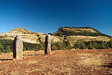
Saint-Étienne-du-Valdonnez is located west of Lozère , about 15 km south of Mende in the Bramont valley . Like that of the neighboring Les Bondons , the municipality marker overlaps with the 10 km² high plateau Cham des Bondons . There are menhirs , including the Pierre des trois Paroisses .
Web links
Commons : Saint-Étienne-du-Valdonnez - Collection of images, videos and audio files

