
Altier
| Altier | ||
|---|---|---|

|
|
|
| region | Occitania | |
| Department | Lozère | |
| Arrondissement | Mende | |
| Canton | Saint-Etienne-du-Valdonnez | |
| Community association | Mont Lozère | |
| Coordinates | 44 ° 28 ′ N , 3 ° 52 ′ E | |
| height | 616-1,678 m | |
| surface | 54.45 km 2 | |
| Residents | 202 (January 1, 2017) | |
| Population density | 4 inhabitants / km 2 | |
| Post Code | 48800 | |
| INSEE code | 48004 | |
| Website | http://altier48.free.fr/ | |

Altier is a French commune in the department of Lozère in the region Occitania . It is about 650 meters above sea level and has 202 inhabitants (as of January 1, 2017).
It is located in the southern Massif Central in the Cevennes region ; the highest mountain in the Cevennes, Mont Lozère , is about 20 km southwest of the municipality.
Altier is located in the valley of the river Altier of the same name , which flows from Mont Lozère over Lac de Villefort into Chassezac and further into Ardèche .
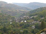
Altier in the valley of the river of the same name

Château du Champ near Altier


Web links
Commons : Altier - collection of images, videos and audio files