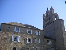
Chaudeyrac
| Chaudeyrac | ||
|---|---|---|
|
|
||
| region | Occitania | |
| Department | Lozère | |
| Arrondissement | Mende | |
| Canton | Grandrieu | |
| Community association | Randon Margeride | |
| Coordinates | 44 ° 40 ′ N , 3 ° 45 ′ E | |
| height | 1,119-1,436 m | |
| surface | 44.10 km 2 | |
| Residents | 305 (January 1, 2017) | |
| Population density | 7 inhabitants / km 2 | |
| Post Code | 48170 | |
| INSEE code | 48045 | |
Chaudeyrac is a French commune with 305 inhabitants (as of January 1, 2017) in the Lozère department in the Occitanie region (before 2016 Languedoc-Roussillon ). It belongs to the canton of Grandrieu and the arrondissement of Mende .
Geography, infrastructure
Chaudeyrac lies in the area of the Massif Central . This is where the Route nationale 500 ended . The local section was taken over from the RN 88 . The neighboring municipalities are Pierrefiche in the northwest, Rocles in the northeast, Cheylard-l'Évêque in the east, Saint-Frézal-d'Albuges in the southeast, Montbel in the south and Châteauneuf-de-Randon in the west. The municipality is affected by the Clamouse River .
Population development
| year | 1962 | 1968 | 1975 | 1982 | 1990 | 1999 | 2008 | 2015 |
|---|---|---|---|---|---|---|---|---|
| Residents | 438 | 414 | 327 | 296 | 235 | 263 | 302 | 310 |
Attractions
- Romanesque church of Saint-Martin
Web links
Commons : Chaudeyrac - collection of images, videos and audio files

