Saint-Léger-du-Malzieu
|
Saint-Léger-du-Malzieu Sent Latgièr del Malasiu |
||
|---|---|---|
|
|
||
| region | Occitania | |
| Department | Lozère | |
| Arrondissement | Mende | |
| Canton | Saint-Alban-sur-Limagnole | |
| Community association | Terres d'Apcher-Margeride-Aubrac | |
| Coordinates | 44 ° 53 ′ N , 3 ° 19 ′ E | |
| height | 797-1,184 m | |
| surface | 18.92 km 2 | |
| Residents | 215 (January 1, 2017) | |
| Population density | 11 inhabitants / km 2 | |
| Post Code | 48140 | |
| INSEE code | 48169 | |
Saint-Léger-du-Malzieu ( Occitan : Sent Latgièr del Malasiu ) is a southern French municipality with 215 inhabitants (as of January 1, 2017) in the Lozère department in the Occitania region . The municipality belongs to the arrondissement of Mende and the canton of Saint-Alban-sur-Limagnole (until 2015: canton of Le Malzieu-Ville ). The inhabitants are called Saint-Légérois .
location
Saint-Léger-du-Malzieu is located in the area of the Causse de Sauveterre in the south massif Central in the Cevennes in the historical landscape of Gevaudan . Saint-Léger-du-Malzieu is surrounded by the neighboring communities of Julianges in the north, Saint-Privat-du-Fau in the east and northeast, Le Malzieu-Forain in the southeast, Le Malzieu-Ville in the south, Blavignac in the west and southwest and Chaulhac in the Northwest.
Population development
| year | 1962 | 1968 | 1975 | 1982 | 1990 | 1999 | 2006 | 2013 |
| Residents | 352 | 330 | 283 | 263 | 235 | 189 | 210 | 204 |
| Source: Cassini and INSEE | ||||||||
Attractions
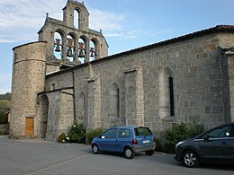
- Saint-Barthélémy church

