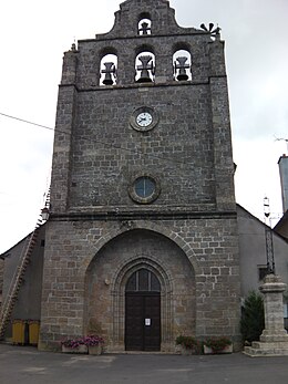
Saint-Germain-du-part
|
Saint-Germain-du-part Sent German del Telh |
||
|---|---|---|

|
|
|
| region | Occitania | |
| Department | Lozère | |
| Arrondissement | Mende | |
| Canton | Chirac | |
| Community association | Aubrac Lot Causses Tarn | |
| Coordinates | 44 ° 29 ′ N , 3 ° 10 ′ E | |
| height | 520-1,122 m | |
| surface | 22.58 km 2 | |
| Residents | 889 (January 1, 2017) | |
| Population density | 39 inhabitants / km 2 | |
| Post Code | 48340 | |
| INSEE code | 48156 | |
Saint-Germain-du-Teil ( Occitan : Sent German del Telh ) is a southern French municipality with 889 inhabitants (as of January 1, 2017) in the Lozère department in the Occitanie region . The municipality belongs to the arrondissement of Mende and the canton of Chirac (until 2015: canton of Saint-Germain-du-Teil ).
location
Saint-Germain-du-Teil is located in the area of the Causse de Sauveterre in the south massif Central in the Cevennes in the historical landscape of Gevaudan . Saint-Germain-du-Teil is surrounded by the neighboring communities of Les Salces in the north and northwest, Bourgs sur Colagne in the northeast, La Canourgue in the east and southeast, Banassac-Canilhac with Banassac in the south, and Saint-Pierre-de-Nogaret in the west as well Les Hermaux to the west and north-west.
Population development
| year | 1962 | 1968 | 1975 | 1982 | 1990 | 1999 | 2006 | 2013 |
| Residents | 698 | 760 | 704 | 779 | 804 | 803 | 832 | 821 |
| Source: Cassini and INSEE | ||||||||
Attractions
- 19th century Saint-Germain church

