
Le Malzieu-Ville
|
Le Malzieu-Ville Lo Malasiu |
||
|---|---|---|

|
|
|
| region | Occitania | |
| Department | Lozère | |
| Arrondissement | Mende | |
| Canton | Saint-Alban-sur-Limagnole | |
| Community association | Terres d'Apcher-Margeride-Aubrac | |
| Coordinates | 44 ° 51 ′ N , 3 ° 20 ′ E | |
| height | 826–1,063 m | |
| surface | 7.8 km 2 | |
| Residents | 730 (January 1, 2017) | |
| Population density | 94 inhabitants / km 2 | |
| Post Code | 48140 | |
| INSEE code | 48090 | |
| Website | http://www.gevaudan.com/ | |
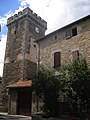
 Town hall (Mairie) of Le Malzieu-Ville with the Bodon tower |
||

Le Malzieu-Ville ( Occitan : Lo Malasiu ) is a southern French municipality with 730 inhabitants (as of January 1, 2017) in the Lozère department in the Occitanie region . The municipality belongs to the Arrondissement of Mende and Saint-Alban-sur-Limagnole (until 2015: Canton Le Malzieu-Ville ). The inhabitants are called Malzéviens .
location
Le Malzieu-Ville is located in the area of the Causse de Sauveterre in the south massif Central in the Cevennes in the historical landscape of Gevaudan . Le Malzieu-Ville is surrounded by the neighboring communities of Saint-Léger-du-Malzieu in the north, Le Malzieu-Forain in the east, Prunières in the south, Saint-Pierre-le-Vieux in the west and south-west and Blavignac in the north-west.
Population development
| year | 1962 | 1968 | 1975 | 1982 | 1990 | 1999 | 2006 | 2013 |
| Residents | 802 | 794 | 874 | 924 | 947 | 970 | 890 | 749 |
| Source: Cassini and INSEE | ||||||||
Attractions
- Collegiate Church of Saint-Hippolyte, original church from the 13th century destroyed during the Huguenot Wars in 1573, rebuilt in 1582
- historical fortifications
- Ursuline Convention

Saint-Hippolyte Church
Beffroi in the fortification


Personalities
- Vital de Lestang (1588–1652), Bishop of Carcassonne
- Louis d'Aurelle de Paladines (1804–1877), General
- Léon Soulier (1924–2016), Bishop of Limoges
- René Souchon (* 1943), politician (PS), Mayor of Aurillac (1977–1995, 2001–2006), State Secretary for Agriculture and Forests (1983–1986)