Prévenchères
|
Prévenchères Prevenchièiras |
||
|---|---|---|
|
|
||
| region | Occitania | |
| Department | Lozère | |
| Arrondissement | Mende | |
| Canton | Saint-Etienne-du-Valdonnez | |
| Community association | Mont Lozère | |
| Coordinates | 44 ° 31 ' N , 3 ° 55' E | |
| height | 337-1,294 m | |
| surface | 62.75 km 2 | |
| Residents | 254 (January 1, 2017) | |
| Population density | 4 inhabitants / km 2 | |
| Post Code | 48800 | |
| INSEE code | 48119 | |
| Website | Prévenchères | |
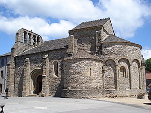
 Prévenchères - Église Saint-Pierre |
||
Prévenchères ( Prevenchièiras in Occitan ) is a southern French town and municipality ( commune ) with 254 inhabitants (as of January 1, 2017) in the Lozère department in the Occitanie region .
location
Prévenchères is about 845 meters above sea level. d. M. on the upper reaches of the Chassezac river in the southern massif central in the Cevennes region . The highest mountain in the Cevennes, Mont Lozère , is about 25 kilometers southwest of the town, the nearest larger city is Mende, about 45 kilometers (driving distance) to the west . The long-distance hiking trail GR 72 runs through the area of the municipality.
Population development
| year | 1800 | 1851 | 1901 | 1954 | 1990 | 1999 | 2006 |
| Residents | 991 | 1,019 | 889 | 465 | 192 | 215 | 266 |
The significant population decline that began in the first half of the 20th century is mainly due to the departure of many families due to the loss of jobs as a result of the mechanization of agriculture . Migration has been positive again since 1982, but there has been a natural population decline, which is slightly more than offset by the influx.
economy
Traditionally, agriculture and primarily sheep breeding play the most important role in the economic life of the municipality. Since the 1960s and 1970s, tourism has been added as a source of income in the form of the rental of holiday homes ( gîtes ).
history
The town's Romanesque church is first mentioned in a document from 1119 as the priory church of the Abbey of Saint-Gilles . The Hundred Years War (1337-1453) passed the place without a trace, but during the Huguenot Wars (1562-1598) eleven priests were executed in the place; the hamlet of Ranc was also destroyed.
Attractions
- The former priory and parish church Saint-Pierre is a building from the mid-12th century, which - except for the unadorned western facade and the four-piece bell gable mostly from virtually uncut - rubble is built. The cloverleaf-shaped constellation ( trikonchos ) of the three apses in the east of the church was unusual ; however, the northern apse was replaced by a rectangular chapel in the 15th century. While the much larger central apse is structured by arched arcades and windows with inserted pillars, the southern apse remained completely undivided, although a comparable structure was provided here - recognizable by the small plinths. The multi-tiered south portal, framed by two buttresses , is otherwise completely unadorned. The crossing tower, which is also accompanied by buttresses, only slightly towers over the roofs of the church; it closes with a gable roof . All roofs of the church with small stone shingles ( roofing stones ) covered. The crossing of the single nave, barrel-vaulted church is spanned by a dome resting on trumpets ; the interior of the central apse shows an arcade structure similar to that of the exterior. The church building was recognized as a monument historique in 1931 .
- The remaining parts of the former priory were also recognized as Monument historique in 1931 .

- Many houses in the village are also built from quarry stone, one from the 16th century with stone window crosses has been under protection since 1942.
- In the village square south of the church there is a linden tree that is more than 400 years old, which - according to local tradition - on the occasion of the birth of Louis XIII. was planted.
- Outstanding feature of the outlying ( 44 ° 29 ′ 44 ″ N , 3 ° 56 ′ 48 ″ E ) and originally from the 11th century, but revised in the 15th century, the Château du Roure is its medieval keep ( donjon ). The castle is privately owned and has been classified as a Monument historique since 1975 .
- The village of La Garde-Guérin , belonging to the municipality , has been included in the list of the most beautiful villages in France . The small Romanesque local church has been recognized as a monument historique since 1928 .
Web links
- Prévenchères, church and village linden - photos
- Prévenchères, Château du Roure - photo + brief information (French)
Individual evidence
- ↑ Église Saint-Pierre, Prévenchères in the Base Mérimée of the French Ministry of Culture (French)
- ↑ Prieuré, Prévenchères in the Base Mérimée of the French Ministry of Culture (French)
- ↑ Maison, Prévenchères in the Base Mérimée of the French Ministry of Culture (French)
- ↑ Château du Roure, Prévenchères in the Base Mérimée of the French Ministry of Culture (French)
- ↑ Église Saint-Michel, La Garde-Guérin, Prévenchères in the Base Mérimée of the French Ministry of Culture (French)

