Altier (river)
| Altier | ||
|
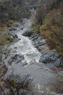
The Altier flows through a narrow gorge between the village of Altier and Villefort |
||
| Data | ||
| Water code | FR : V5040660 | |
| location | France , Occitania region | |
| River system | Rhône | |
| Drain over | Chassezac → Ardèche → Rhône → Mediterranean | |
| source | in the municipal area of Cubières 44 ° 25 ′ 45 ″ N , 3 ° 45 ′ 5 ″ E |
|
| Source height | approx. 1590 m | |
| muzzle | near Pied-de-Borne in the Chassezac coordinates: 44 ° 28 ′ 32 " N , 3 ° 58 ′ 48" E 44 ° 28 ′ 32 " N , 3 ° 58 ′ 48" E |
|
| Mouth height | approx. 320 m | |
| Height difference | approx. 1270 m | |
| Bottom slope | approx. 33 ‰ | |
| length | 39 km (see notes) | |
| Reservoirs flowed through | Lac de Villefort | |
The Altier is a river in France that runs in the Lozère department in the Occitanie region . Its source stream Ruisseau de Banassac rises in the Cevennes National Park , in the area of Mont Lozère , on the northeast flank of the Sommet de Finiels (1699 m), in the municipality of Cubières . It generally drains north-east to east and after 39 kilometers flows into the Chassezac as a right tributary near Pied-de-Borne . In the middle part, the Altier flows through the artificial reservoir Lac de Villefort .
Places on the river
Web links
Commons : Altier - collection of images, videos and audio files
