Serris
| Serris | ||
|---|---|---|
|
|
||
| region | Île-de-France | |
| Department | Seine-et-Marne | |
| Arrondissement | Torcy | |
| Canton | Serris (main town) | |
| Community association | Val d'Europe agglomeration | |
| Coordinates | 48 ° 51 ' N , 2 ° 47' E | |
| height | 123-133 m | |
| surface | 5.6 km 2 | |
| Residents | 9,040 (January 1, 2017) | |
| Population density | 1,614 inhabitants / km 2 | |
| Post Code | 77700 | |
| INSEE code | 77449 | |
| Website | www.mairie-serris.net/ | |
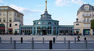
 Ariane Square in Serris |
||
Serris is a French municipality with 9040 inhabitants (at January 1, 2017) in the department of Seine-et-Marne in the region Ile-de-France east of Paris . Serris belongs to the Arrondissement of Torcy and the Canton of Serris . The inhabitants are called Serrisiens . Serris belongs to the Ville nouvelle Marne-la-Vallée .
geography
Serris is about 37 kilometers east of Paris. Serris is surrounded by Chessy and Coupvray in the north, Magny-le-Hongre in the northeast, Bailly-Romainvilliers in the east, Villeneuve-Saint-Denis in the south, Jossigny in the west and Montévrain in the northwest.
The A4 Autoroute runs through the municipality from Paris to the east of France.
Population development
| 1962 | 1968 | 1975 | 1982 | 1990 | 1999 | 2006 | 2011 | 2014 |
|---|---|---|---|---|---|---|---|---|
| 207 | 232 | 304 | 422 | 898 | 2,320 | 6,061 | 7,866 | 8,603 |
| Sources: Cassini and INSEE | ||||||||
In the next few years the population of Serris will continue to increase sharply, as the municipality is part of the new development area Val d'Europe in the 4th sector of the Ville nouvelle Marne-la-Vallée .
Attractions
See also: List of Monuments historiques in Serris
- A small part of Disneyland Paris is in the northern part of the municipal area
- Ruins from the Merovingian period
literature
- Le Patrimoine des Communes de la Seine-et-Marne . Flohic Editions, Volume 2, Paris 2001, ISBN 2-84234-100-7 , pp. 1405-1406.

