
Château-Thierry
| Château-Thierry | ||
|---|---|---|

|
|
|
| Country | France | |
| region | Hauts-de-France | |
| Department (no.) | Aisne (02) | |
| Arrondissement | Château-Thierry | |
| Canton | Château-Thierry | |
| Community association | Communauté d'agglomération de la Région de Château-Thierry | |
| Coordinates | 49 ° 3 ' N , 3 ° 24' E | |
| height | 59– 222 m | |
| surface | 17.01 km² | |
| Residents | 15,351 (January 1, 2018) | |
| Population density | 902 inhabitants / km² | |
| Post Code | 02400 | |
| INSEE code | 02168 | |
| Website | www.ville-chateau-thierry.fr | |
 City Hall (left) and Tour Balhan |
||

Château-Thierry is a French municipality with 15,351 inhabitants (at January 1, 2018) in the region of Hauts-de-France . It is one of the sub-prefectures of the Aisne department and the seat of the Région de Château-Thierry municipal association .
geography
Château-Thierry is located on the Marne , about halfway between Paris and Reims .
Surname
According to the local legend, the city is named after a castle in which Karl Martell Theuderich IV is said to have been imprisoned. In the era of the French Revolution , the city was renamed Château Égalité in 1793, according to the fashion of the time . It was later renamed Égalité-sur-Marne , to finally return to the original name.
history
On February 12, 1814, the town and the surrounding area were the scene of the battle of Château-Thierry between the French on one side and the Russians and Prussians on the other during the winter campaign of 1814 .

During the First World War , the city was reached by German troops during the Aisne-Marne offensive ( Blücher attack ) in May 1918. As a result, there were several months of fighting against units of the American Expeditionary Forces , which had been ordered to the front in support of the beleaguered French army. The Américain monument , erected above the city, commemorates these battles and the battle of Château-Thierry on July 18, 1918 .
Also in the western campaign of the Second World War , Château-Thierry was a site of fighting and suffered destruction when the Wehrmacht crossed the Marne here in the case of Rot .
Population development
| year | 1962 | 1968 | 1975 | 1982 | 1990 | 1999 | 2007 | 2016 |
| Residents | 10,006 | 11,049 | 13,491 | 14,557 | 15,312 | 14,966 | 14,794 | 14,847 |
traffic


Château-Thierry has a train station on the Paris – Strasbourg line , which was opened in this area on September 2, 1849 by the Compagnie des Chemins de fer de l'Est . In 1885 the branch to Breny was added. From 1910 to 1942 the place was the starting point of a narrow-gauge railway network of the Compagnie des chemins de fer du Sud de l'Aisne .
The former national road N 3 ("Route d'Allemagne"), which crosses Château-Thierry in an east-west direction, was downgraded to the departmental roads D 3 and D 1003. Runs from north to south in the department road D 1, the highway A 4 (Paris- Strasbourg ) tangent to the municipal area at the northern edge.
Tourist Attractions
- Hôtel Dieu de Château-Thierry , Monument historique
- Hôtel de ville (Town Hall), Monument historique
- Remains of the Château-Thierry castle, Monument historique
- Saint-Crépin church, historic monument
- American memorial at Château-Thierry

Hôtel Dieu

town hall
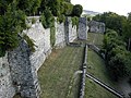
Inside of the castle

Saint-Crépin church


Town twinning
-
 Mosbach in Baden-Wuerttemberg
 -
Pößneck in Thuringia
-
Unterlüß in Lower Saxony
-
 Aliartos in Greece
 -
 Cisnădie in Romania
 -
 Kinyami in Rwanda
 -
 Grybów in Poland
 -
 Ambohitrolomahitsy in Madagascar
Personalities
- Jean de La Fontaine (1621–1695), fabulous poet
- Maurice Holleaux (1861–1932), Graecist, ancient historian, epigraphist and classical archaeologist
- Alain Weber (1930–2019), composer
- Yves Bot (1947–2019), lawyer and advocate general at the Court of Justice of the European Communities
- Emmanuel Grenier (* 1970), mathematician
Individual evidence
- ^ Jean-Pierre Rigouard: Paris – Strasbourg. De la Compagnie de l'Est au TGV . 1st edition. Editions Alan Sutton, Saint-Cyr-sur-Loire 2006, ISBN 978-2-84910-550-4 , pp. 31 .
- ↑ Hôtel Dieu in the Base Mérimée of the French Ministry of Culture (French)
- ↑ Town Hall in the Base Mérimée of the French Ministry of Culture (French)
- ↑ Castle Château-Thierry in the Base Mérimée of the French Ministry of Culture (French)
- ^ Church of Saint-Crépin in the Base Mérimée of the French Ministry of Culture (French)
Web links