Fresnes-en-Tardenois
| Fresnes-en-Tardenois | ||
|---|---|---|
|
|
||
| region | Hauts-de-France | |
| Department | Aisne | |
| Arrondissement | Château-Thierry | |
| Canton | Fère-en-Tardenois | |
| Community association | Communauté d'agglomération de la Région de Château-Thierry | |
| Coordinates | 49 ° 9 ' N , 3 ° 33' E | |
| height | 133-221 m | |
| surface | 8.84 km 2 | |
| Residents | 268 (January 1, 2017) | |
| Population density | 30 inhabitants / km 2 | |
| Post Code | 02130 | |
| INSEE code | 02332 | |
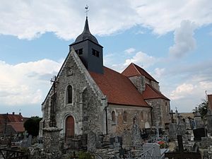
 Église de la Vierge (Church of the Virgin Mary) |
||
Fresnes-en-Tardenois is a French municipality with 268 inhabitants (as of January 1 2017) in the department of Aisne in the region of Hauts-de-France (former Region: Picardie ). The municipality belongs to the arrondissement of Château-Thierry and is part of the canton of Fère-en-Tardenois .
geography
Fresnes-en-Tardenois is located around 20 kilometers northeast of Château-Thierry on the Ru du Paradis, one of the small tributaries of the upper reaches of the Ourcq . In the north of the core community is the castle complex (Château de Fresnes), further the estates of La Cense and La Motte. To the east, part of the Bois de la Garenne forest belongs to the municipality. In the west there is a larger forest area with the site names Les Usages and La Ventelette. To the south, the municipality extends beyond the Autoroute A4 (Autoroute de l'Est) to the route of the LGV Est européenne . The Tardenois Nord and Tardenois Sud motorway service stations are located in the municipality.
Toponymy
The name of the municipality is derived from the name "fraxinus" ( ash ) and the natural landscape of the Tardenois in the border area of the Aisne and Marne departments.
Population development
| year | 1962 | 1968 | 1975 | 1982 | 1990 | 1999 | 2009 | 2017 |
| Residents | 212 | 188 | 211 | 191 | 245 | 263 | 254 | 268 |
| Sources: Cassini and INSEE | ||||||||
Attractions
- Church of the Virgin Mary
