Tamer
| Tamer | ||
|---|---|---|
|
|
||
| region | Hauts-de-France | |
| Department | Aisne | |
| Arrondissement | Château-Thierry | |
| Canton | Essômes-sur-Marne | |
| Community association | Communauté de communes du Canton de Charly-sur-Marne | |
| Coordinates | 49 ° 1 ′ N , 3 ° 17 ′ E | |
| height | 102-203 m | |
| surface | 4.56 km 2 | |
| Residents | 654 (January 1, 2017) | |
| Population density | 143 inhabitants / km 2 | |
| Post Code | 02310 | |
| INSEE code | 02268 | |
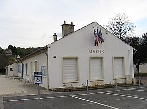
 The Mairie |
||
Domptin is a French municipality with 654 inhabitants (as of January 1 2017) in the department of Aisne in the region of Hauts-de-France (former Region: Picardie ). The municipality belongs to the arrondissement of Château-Thierry and is part of the canton of Essômes-sur-Marne . The inhabitants are known as Domptinois (es) .
geography
The municipality with some vineyards is located north of the Marne on the Ru de Domptin brook around six kilometers north of Charly-sur-Marne on the D11 departmental road. It includes the districts of Les Guillornets, La Baudière and Le Moulinet.
In addition to Charly in the east, neighboring communities are Villiers-Saint-Denis in the south, Bézu-le-Guéry in the west and Coupru in the north.
Population development
| year | 1962 | 1968 | 1975 | 1982 | 1990 | 1999 | 2008 | 2015 |
| Residents | 231 | 219 | 223 | 300 | 420 | 530 | 645 | 664 |
| Source: Cassini and INSEE | ||||||||
Attractions
- Saint-Quentin Church
- Four wash houses
Web links
Commons : Domptin - collection of pictures, videos and audio files

