
Brécy (Aisne)
| Brécy | ||
|---|---|---|
|
||
| region | Hauts-de-France | |
| Department | Aisne | |
| Arrondissement | Château-Thierry | |
| Canton | Château-Thierry | |
| Community association | Region de Château-Thierry | |
| Coordinates | 49 ° 9 ' N , 3 ° 26' E | |
| height | 103-216 m | |
| surface | 9.98 km 2 | |
| Residents | 340 (January 1, 2017) | |
| Population density | 34 inhabitants / km 2 | |
| Post Code | 02210 | |
| INSEE code | 02119 | |

Brécy is a French municipality with 340 inhabitants (as of January 1 2017) in the Aisne department in the region of Hauts-de-France (before 2016: Picardy ); it belongs to the arrondissement of Château-Thierry and the canton of Château-Thierry (until 2015: canton of Fère-en-Tardenois ). The inhabitants are called Les Brécois .
geography
Brécy is located in the Tardenois countryside between Paris and Reims . Brécy is surrounded by the neighboring communities of Coincy in the north and east, Épieds in the south and south-east, Bézu-Saint-Germain in the south and south-west, Rocourt-Saint-Martin in the west and Armentières-sur-Ourcq in the north-west.
Population development
| year | 1962 | 1968 | 1975 | 1982 | 1990 | 1999 | 2006 | 2013 |
| Residents | 201 | 215 | 224 | 183 | 284 | 318 | 340 | 345 |
| Source: Cassini and INSEE | ||||||||
Attractions
- Saint-Michel church from the 12th century, historic monument since 1920
- Le Buisson castle from the 13th century, monument historique since 1981
- Engraved rock from the 5th century, Monument historique since 1975
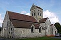
Saint-Michel church
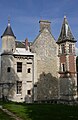
Le Buisson Castle

Engraved rock


.JPG)
Web links
Commons : Brécy - collection of images, videos and audio files