Viffort
| Viffort | ||
|---|---|---|
|
|
||
| region | Hauts-de-France | |
| Department | Aisne | |
| Arrondissement | Château-Thierry | |
| Canton | Essômes-sur-Marne | |
| Community association | Communauté d'agglomération de la Région de Château-Thierry | |
| Coordinates | 48 ° 58 ′ N , 3 ° 28 ′ E | |
| height | 159-224 m | |
| surface | 9.83 km 2 | |
| Residents | 320 (January 1, 2017) | |
| Population density | 33 inhabitants / km 2 | |
| Post Code | 02540 | |
| INSEE code | 02800 | |
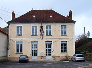
 The Mairie |
||
Viffort is a French municipality with 320 inhabitants (as of January 1 2017) in the department of Aisne in the region of Hauts-de-France (former Region: Picardie ). The municipality belongs to the arrondissement of Château-Thierry and is part of the canton of Essômes-sur-Marne (formerly: canton of Condé-en-Brie ).
geography
The municipality located around eleven kilometers south-southeast of Château-Thierry on the plateau in the former Brie Champenoise with the districts of La Billonnerie, La Fosse aux Larrons, La Malmaison Basse, La Malmaison Haute, Cense Naudé, Sous la Ville, La Commanderie, La Fosse Gaudier, Le Moulin Adam, Chêne Benoît, La Pisserotte, Vilzeaux, Pertibout, La Croisette, La Villeneuve and Gillauche near the D1 departmental road to Montmirail .
history
In 1814 Ludwig Yorck von Wartenburg had his headquarters in Viffort, where a Seigneurie of the Order of Malta was located . In 1914 one of the Marne battles took place there.
Population development
| year | 1962 | 1968 | 1975 | 1982 | 1990 | 1999 | 2009 | 2015 |
| Residents | 249 | 207 | 186 | 207 | 236 | 212 | 328 | 325 |
| Source: Cassini and INSEE | ||||||||
Attractions
- The Church of the Nativity of Mary (Église de la Nativité-de-la-Sainte-Vierge) has a nave from the 12th century; the choir dates from the 13th century, a painted flat ceiling from the 16th century supported by carved beams. It was classified as a Monument historique in 1920 ( Base Mérimée PA00115980).
- Remnants of the Moulin Adam mill
- Wash house

