Saulchery
| Saulchery | ||
|---|---|---|
|
|
||
| region | Hauts-de-France | |
| Department | Aisne | |
| Arrondissement | Château-Thierry | |
| Canton | Essômes-sur-Marne | |
| Community association | Communauté de communes du Canton de Charly-sur-Marne | |
| Coordinates | 48 ° 59 ′ N , 3 ° 18 ′ E | |
| height | 57-180 m | |
| surface | 2.63 km 2 | |
| Residents | 724 (January 1, 2017) | |
| Population density | 275 inhabitants / km 2 | |
| Post Code | 02310 | |
| INSEE code | 02701 | |
| Website | http://www.communaute-charlysurmarne.fr/Saulchery | |
 Town hall and school building |
||
Saulchery is a French municipality with 724 inhabitants (as of January 1 2017) in the department of Aisne in the region of Hauts-de-France (former Region: Picardie ). The municipality belongs to the arrondissement of Château-Thierry and is part of the canton of Essômes-sur-Marne . The inhabitants are called Saulcherien (ne) s .
geography
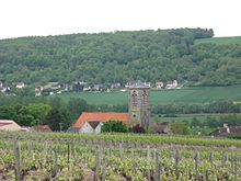
The wine-growing (Appelation Champagne) commune is located 15 kilometers southwest of Château-Thierry in the Marne valley on the orographic right bank between Romeny-sur-Marne (upstream) and Charly-sur-Marne (downstream). The districts of Le Pont and Montoiselle belong to the municipality. Another neighboring community is on the opposite bank of the river Nogent-l'Artaud , which is connected to Le Pont by a road bridge (with train station).
Population development
| year | 1962 | 1968 | 1975 | 1982 | 1990 | 1999 | 2009 | 2017 |
| Residents | 640 | 575 | 579 | 564 | 592 | 661 | 666 | 724 |
| Sources: Cassini and INSEE | ||||||||
Attractions
- Saint-Sébastien church
- Wash house and well
Personalities
- Léon Lemoine, mayor and resistance fighter (1896–1945).
Individual evidence
- ^ Claire Chevrillon: Une résistance ordinaire: septembre 1939-août 1944, Ed. du Félin, 1999

