
Fère-en-Tardenois
| Fère-en-Tardenois | ||
|---|---|---|

|
|
|
| region | Hauts-de-France | |
| Department | Aisne | |
| Arrondissement | Château-Thierry | |
| Canton | Fère-en-Tardenois | |
| Community association | Region de Château-Thierry | |
| Coordinates | 49 ° 12 ' N , 3 ° 31' E | |
| height | 106-225 m | |
| surface | 20.40 km 2 | |
| Residents | 3,053 (January 1, 2017) | |
| Population density | 150 inhabitants / km 2 | |
| Post Code | 02130 | |
| INSEE code | 02305 | |
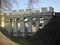
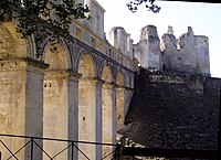
 The ruins of the castle - the symbol of Fère-en-Tardenois |
||

Fere-en-Tardenois is a French municipality with 3053 inhabitants (at January 1, 2017) in the Aisne department in the region of Hauts-de-France ; it belongs to the arrondissement of Château-Thierry and the municipal association Région de Château-Thierry .
geography
The municipality of Fère-en-Tardenois is located on the upper reaches of the Ourcq , about 40 kilometers west of Reims .
history
Events
- The city was conquered on November 29, 1579 by the Protestant military leader Henri I de Bourbon, prince de Condé , and was brought back by the royal troops after a siege in September 1580.
- In the First Marne Battle in 1914 and the Second Marne Battle in 1918 , the city was the scene of fierce fighting.
Lords of Fère-en-Tardenois
- André de Baudement, † 1142 ( House Baudement )
- Guy de Baudement, † 1144
- Agnes de Baudement, † before 1217, Countess von Braine etc., wife of
- Robert I the Great , † 1188 Count von Dreux ( list of the Capetians , House of France-Dreux )
- Anne de Montmorency (1493–1567) Connétable of France , received Fère as a gift from King Francis I on the occasion of his wedding to Luise of Savoy
Population development
| year | 1962 | 1968 | 1975 | 1982 | 1990 | 1999 | 2007 | 2016 |
| Residents | 2419 | 2730 | 3012 | 3246 | 3168 | 3356 | 3306 | 3098 |
Attractions
Fère-en-Tardenois Castle
The architecture of the access bridge is similar to that in Chenonceau Castle . The foundations date from the 13th century. The lower floor served as a passage, the upper floor was reserved for social life. The donjon is an irregular heptagon flanked by seven round towers that the Duke of Orléans had demolished in 1779. The surrounding hunting area is 250 hectares. Today there is a luxury hotel within the ruins of the castle.
More Attractions
Moat
Castle

Market hall
_Ch%C3%A2teau_-_Nojhan_-_DSCN2966.jpg)


Town twinning
A partnership with the Bavarian city of Wertingen has existed since 1989 .
Personalities
- Camille Claudel (1864–1943), sculptor and painter, born here in 1864
literature
- Étienne Moreau-Nélaton, Historie de Fère-en-Tardenois, Paris 1911ff
- L'Aisne , éditions de La Martinière, 1993, textes de Jean-Yves Montagu, ISBN 2-73-242025-5