Pavant
| Pavant | ||
|---|---|---|

|
|
|
| region | Hauts-de-France | |
| Department | Aisne | |
| Arrondissement | Château-Thierry | |
| Canton | Essômes-sur-Marne | |
| Community association | Communauté de communes du Canton de Charly-sur-Marne | |
| Coordinates | 48 ° 57 ′ N , 3 ° 17 ′ E | |
| height | 57-206 m | |
| surface | 5.43 km 2 | |
| Residents | 781 (January 1, 2017) | |
| Population density | 144 inhabitants / km 2 | |
| Post Code | 02310 | |
| INSEE code | 02596 | |
| Website | Pavant.fr | |
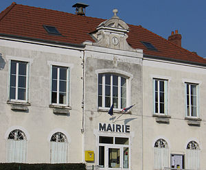
 Mairie Pavant |
||
Pavant is a French municipality with 781 inhabitants (as of January 1 2017) in the department of Aisne in the region of Hauts-de-France (former Region: Picardie ). The municipality belongs to the arrondissement of Château-Thierry and is part of the canton of Essômes-sur-Marne . The inhabitants are known as Pavanais (es) .
geography
The wine-growing community (AOC Champagne) is located on the south bank of the Marne below Nogent-l'Artaud on the border with the Seine-et-Marne department . Charly-sur-Marne connects to the north , from which Pavant is separated by an exclave in the west. In the south, Pavant borders on Bassevelle . The railway line following the valley of the Marne and the D86 departmental road run through the municipality; the D82 departmental road connects to Charly-sur-Marne via a bridge over the Marne.
history
The place is mentioned in 855 as Penvennum. The abandoned castle was built in the time of Louis XIV under the direction of the architect Louis Le Vau .
Population development
| year | 1962 | 1968 | 1975 | 1982 | 1990 | 1999 | 2009 | 2017 |
| Residents | 497 | 511 | 589 | 665 | 732 | 753 | 792 | 781 |
| Sources: Cassini and INSEE | ||||||||
Attractions
- Saint-Bald church with a Romanesque portal
- Pigeon house (end of the 15th century)
- Aqueduc de la Dhuis

