Ronchères (Aisne)
| Ronchères | ||
|---|---|---|
|
|
||
| region | Hauts-de-France | |
| Department | Aisne | |
| Arrondissement | Château-Thierry | |
| Canton | Fère-en-Tardenois | |
| Coordinates | 49 ° 9 ′ N , 3 ° 36 ′ E | |
| height | 149-227 m | |
| surface | 6.06 km 2 | |
| Residents | 112 (January 1, 2017) | |
| Population density | 18 inhabitants / km 2 | |
| Post Code | 02130 | |
| INSEE code | 02655 | |
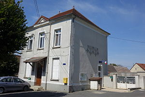
 The Mairie (Mayor's Office) |
||
Ronchères is a French commune of 112 inhabitants (as of January 1, 2017) in the department of Aisne in the region of Hauts-de-France (former Region: Picardie ). The municipality belongs to the arrondissement of Château-Thierry and is part of the canton of Fère-en-Tardenois .
geography
Ronchères is located around 25 kilometers northeast of Château-Thierry on the border of the Aisne and Marne departments, not far from the source of the Ourcq, mostly north of the A 4 autoroute (Autoroute de l'Est) and the LGV Est européenne . To the south of these traffic routes are the Bois de la Forge group of houses and the Bois du Prieuré forest .
Toponymy
The place was referred to in 1205 as "Runcheriae".
Population development
| year | 1962 | 1968 | 1975 | 1982 | 1990 | 1999 | 2010 | 2015 |
| Residents | 122 | 112 | 109 | 114 | 135 | 111 | 130 | 114 |
| Source: Cassini and INSEE | ||||||||
Attractions
- Saint-Germain-l'Auxerrois church
- War memorial
Individual evidence
- ^ Ernest Nègre: Toponymie générale de la France, Vol. 2, Librairie Droz, 1996, Sp. 1257, ISBN 9782600001335
Web links
Commons : Ronchères - Collection of images, videos and audio files

