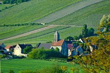
Monthurel
| Monthurel | ||
|---|---|---|
|
|
||
| region | Hauts-de-France | |
| Department | Aisne | |
| Arrondissement | Château-Thierry | |
| Canton | Essômes-sur-Marne | |
| Community association | Communauté d'agglomération de la Région de Château-Thierry | |
| Coordinates | 49 ° 1 ′ N , 3 ° 33 ′ E | |
| height | 71-237 m | |
| surface | 3.86 km 2 | |
| Residents | 151 (January 1, 2017) | |
| Population density | 39 inhabitants / km 2 | |
| Post Code | 02330 | |
| INSEE code | 02510 | |
 Mairie Monthurel |
||
Monthurel is a French municipality with 151 inhabitants (as of January 1 2017) in the department of Aisne in the region of Hauts-de-France (former Region: Picardie ). The municipality belongs to the arrondissement of Château-Thierry and is part of the canton of Essômes-sur-Marne (formerly: canton of Condé-en-Brie ).
geography
The wine-growing community with the districts Couberchy and Les Bourguignons is located east of the Surmelin river between Connigis and Celles-lès-Condé around 14 kilometers east-southeast of Château-Thierry near Condé-en-Brie ; on the opposite side of the valley is Saint-Eugène . The municipality extends in the east up to the height and shares in the forest Bois de Condé. There the community also borders on Reuilly-Sauvigny and the large community of Vallées en Champagne .
Population development
| year | 1962 | 1968 | 1975 | 1982 | 1990 | 1999 | 2011 | 2017 |
| Residents | 80 | 96 | 94 | 122 | 117 | 121 | 147 | 151 |
| Sources: Cassini and INSEE | ||||||||
Attractions
- Saint-Éloi church from the 13th century
- Three wash houses


