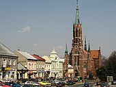
Grybów
| Grybów | ||
|---|---|---|

|
|
|
| Basic data | ||
| State : | Poland | |
| Voivodeship : | Lesser Poland | |
| Powiat : | Nowy Sącz | |
| Area : | 17.00 km² | |
| Geographic location : | 49 ° 37 ' N , 20 ° 57' E | |
| Height : | 330 m npm | |
| Residents : | 6026 (June 30, 2019) |
|
| Postal code : | 33-330 | |
| Telephone code : | (+48) 18 | |
| License plate : | KNS | |
| Economy and Transport | ||
| Street : | DK28 Nowy Sącz - Biecz | |
| Ext. 981 Krynica-Zdrój - Ciężkowice | ||
| Rail route : | Krakow - Tarnów - Nowy Sącz | |
| Next international airport : | Krakow-Balice | |
| Rzeszów-Jasionka | ||
| Gmina | ||
| Gminatype: | Borough | |
| Residents: | 6026 (June 30, 2019) |
|
| Community number ( GUS ): | 1210011 | |
| Administration (as of 2008) | ||
| Mayor : | Piotr Piechnik | |
| Address: | ul.Rynek 12 33-330 Grybów |
|
| Website : | www.grybow.pl | |
Grybów is a city in Poland in the Lesser Poland Voivodeship . Grybów belongs to the Nowosądecki powiat and has about 6,000 inhabitants (2015). The city forms its own municipality (gmina miejska) and is the seat of the independent rural municipality Grybów .
Geographical location
Grybów is located in the south of the Lesser Poland Voivodeship, about 30 kilometers north of Poland's state border with Slovakia . The city is located in the Western Carpathians in the Beskid Sądecki (Sandezer Beskids) .
history
Today's Grybów goes back to the layout of the place Grynberk , Grymberk or Tymberch (the Middle High German name would be Grünberg today ) in 1340. In 1346 it was mentioned once as Grewstat . The current Polonized name Grybowa appeared as Grebow in 1365 or 1388 .
The city should serve, among other things, to secure the southern border of Poland. Since the houses were made of wood, large parts of the village were victims of fires several times; But the city was also destroyed several times by the effects of war, such as during the Northern Wars . After Poland was embroiled in the chaos of war by the Confederation of Bar in 1786 , Austria occupied parts of the Carpathians in 1770, including Grybów. Thus, the city had become part of Austria even before the First Partition of Poland . In 1876 the place was connected to the rail network.
After the First World War , Grybów became part of the re-established Poland. On 6./7. In September 1939 the city was taken by the Wehrmacht during the attack on Poland . At the end of World War II , the city was captured by the Red Army during the Western Carpathian Operation . To defend the city, the German Wehrmacht destroyed the bridge and the viaduct. At the end of the war, about two thirds of the city was destroyed; it again became part of Poland.
Rural community
The rural community (gmina wiejska) Grybów has an area of 153 km² and 16 districts with a Schulzenamt .
traffic
The state road 28 (droga krajowa 28) runs through Grybów from east to west and the provincial road 981 (droga wojewódzka 981) from north to south . After about 15 kilometers in a westerly direction, the national road 28 leads to Nowy Sącz , at the same distance in an easterly direction the road goes through Gorlice . The provincial road 981 crosses the state road 75 in the south at a distance of about 18 kilometers and after a further five kilometers leads to Krynica-Zdrój . In a northerly direction, the 981 leads to Ciężkowice after about 25 kilometers .
The city has its own train station with direct connections to Kraków , Tarnów and Nowy Sącz .
The nearest international airport is John Paul II Airport, Krakow-Balice, about 100 kilometers to the north-west . The Rzeszóz Airport is about the same distance to the northeast.
Architectural monuments
- Synagogue , built in 1909
education
Grybów has two primary schools (Szkoła Podstawowa) , a secondary school (Gimnazjum im. Stanisława Konarskiego ) and a high school (Liceum Ogólnokształcące im. Artura Grottgera ) . There is also a vocational school (Zespół Szkół Zawodowych im. Stanisława Staszica )
Sons and daughters
- Tomasz Poręba (* 1973), politician
Web links
- City website (Polish)
Individual evidence
- ↑ a b population. Size and Structure by Territorial Division. As of June 30, 2019. Główny Urząd Statystyczny (GUS) (PDF files; 0.99 MiB), accessed December 24, 2019 .
- ^ Tomasz Jurek (editor): GRYBÓW ( pl ) In: Słownik Historyczno-Geograficzny Ziem Polskich w Średniowieczu. Edycja elektroniczna . PAN . 2010-2016. Retrieved April 22, 2019.
- ↑ mapa.szukacz.pl: Grybów - Informacje dodatkowe accessed on January 22, 2008


