Corenc
| Corenc | ||
|---|---|---|

|
|
|
| region | Auvergne-Rhône-Alpes | |
| Department | Isère | |
| Arrondissement | Grenoble | |
| Canton | Meylan | |
| Community association | Grenoble-Alpes metropolis | |
| Coordinates | 45 ° 13 ' N , 5 ° 45' E | |
| height | 221-1,328 m | |
| surface | 6.5 km 2 | |
| Residents | 4,013 (January 1, 2017) | |
| Population density | 617 inhabitants / km 2 | |
| Post Code | 38700 | |
| INSEE code | 38126 | |
| Website | http://www.ville-corenc.fr/ | |
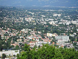
 View of La Tronche and Corenc |
||
Corenc is a French municipality with 4013 inhabitants (as of January 1 2017) in the department of Isère in the region Auvergne Rhône-Alpes . It belongs to the Arrondissement of Grenoble and the Canton of Meylan . The inhabitants call themselves Corençais (es) .
geography
Corenc is located on Grenoble opposite the banks of the Isère . Corenc is surrounded by the neighboring communities Quaix-en-Chartreuse in the north and north-west, Le Sappey-en-Chartreuse in the north-east, Meylan in the east and south-east and La Tronche in the west and south-west.
Population development
| year | 1962 | 1968 | 1975 | 1982 | 1990 | 1999 | 2006 | 2012 |
| Residents | 2,510 | 2,850 | 3,029 | 3.138 | 3,356 | 3,856 | 3,784 | 3,944 |
Attractions
- Saint-Pierre church from 1862
- Sainte-Thérèse church from 1930
- Old Montfleury convent from the 13th and 15th centuries
- Ruins of the La Providence convent, called Le Mollard Castle
- 15th century Bouquéron castle with Saint-Blaise chapel
- Arvilliers Castle, fortified house from the 15th / 16th centuries century
- La Condamine Castle, today's town hall, built at the beginning of the 20th century
- Matel Castle from the 16th century
- Le Cizerain castle from the 17th century
- Fort Bourcet
Personalities
- Jules Flandrin (1871-1947), painter
Web links
Commons : Corenc - collection of images, videos and audio files
