
Revel (Isere)
| Revel | ||
|---|---|---|
|
||
| region | Auvergne-Rhône-Alpes | |
| Department | Isère | |
| Arrondissement | Grenoble | |
| Canton | Le Moyen Grésivaudan | |
| Community association | Le Grésivaudan | |
| Coordinates | 45 ° 11 ′ N , 5 ° 52 ′ E | |
| height | 299-2,840 m | |
| surface | 29.55 km 2 | |
| Residents | 1,314 (January 1, 2017) | |
| Population density | 44 inhabitants / km 2 | |
| Post Code | 38420 | |
| INSEE code | 38334 | |
| Website | http://www.revel-belledonne.com/ | |
_mairie_et_%C3%A9coles_abc12.JPG) Town Hall (Mairie) of Revel |
||

Revel is a French commune with 1,314 inhabitants (as of January 1 2017) in the department of Isère in the region Auvergne Rhône-Alpes . It belongs to the Arrondissement of Grenoble and is part of the canton of Le Moyen Grésivaudan . The inhabitants are called Revélois .
geography
Revel is about eighteen kilometers east of Grenoble in the Grésivaudan countryside on the Belledonne mountain range . Revel is surrounded by the neighboring communities of Saint-Jean-le-Vieux and La Combe-de-Lancey in the north, Allemond in the east, Livet-et-Gavet in the southeast, Vaulnaveys-le-Haut and Saint-Martin-d'Uriage in the south and south-west and Murianette and Saint-Ismier in the north-west.
Population development
| 1962 | 1968 | 1975 | 1982 | 1990 | 1999 | 2006 | 2013 | |
|---|---|---|---|---|---|---|---|---|
| 328 | 280 | 367 | 573 | 875 | 1,162 | 1,283 | 1,390 | |
| Sources: Cassini and INSEE | ||||||||
Attractions
- church
- Castle ruins
- Mill
- Sommiers tower
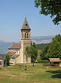
church

Castle ruins

Sommiers tower
_%C3%A9glise_abc17.jpg)

_1.jpg)
Web links
Commons : Revel - collection of images, videos and audio files