Belledonne
| Belledonne | |
|---|---|
| Highest peak | Grand Pic de Belledonne ( 2977 m ) |
| location | mainly in the Isère department , northeast slopes in Savoie , France |
| part of | French Western Alps |
| Coordinates | 45 ° 10 ′ N , 6 ° 0 ′ E |
The Belledonne is an approximately 60 km long mountain range made up of crystalline rock in eastern France and forms the western foothills of the French Alps . The massif stretches from Grenoble to the east and northeast and reaches heights of up to 2980 m on its southern edge (15 km from the city) . It is located in the Isère department , the northeast side also in the Savoie department , directly east of the Isère and the pre-Alpine Chartreuse mountains.
Geographically, the mountains can still be assigned to the Dauphiné Alps , which, however, rise up to 4000 m in the neighboring Pelvoux , and geologically belong to the Central Massif of the Western Alps . In the east it borders on the Vanoise massif (up to 3800 m ), which leads over the upper Isère to the Montblanc massif .
In the southwest lies the Grenoble ski area, Chamrousse .
summit
The highest peak is the Grand Pic de Belledonne with a height of 2977 m . Other high peaks are:
- Pic Central de Belledonne ( 2945 m )
- Rocher Blanc ( 2928 m )
- Croix de Belledonne ( 2926 m )
- Aiguille Michel, the highest point of the Aiguilles de l'Argentière ( 2915 m )
- Rocher Badon ( 2912 m )
- Pyramid ( 2912 m )
- Puy Gris ( 2908 m )
- Grande Lance d'Allemond ( 2842 m )
- Pic du Grand Doménon ( 2802 m )
- Grande Lance de Domène ( 2790 m )
- Grand Charnier d'Allemond ( 2777 m )
Refuges
- Refuge de la Pra 2109 m
- Refuge du Pré du Molard 1735 m
- Refuge Jean Collet 1952 m
- Refuge des Sept Laux 2135 m
- Refuge de la Combe Madame 1784 m
- Refuge de l'Oule (du Antoine Cros) 1836 m
- Refuge de la Piere du Carré 1761 m
- Refuge de Claran 1775 m
photos
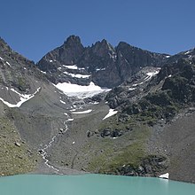
Lac Belledonne with the Grand Charnier d'Allemond ( 2777 m ) behind it
Lac du Crozet with shelter hut
Rocher Blanc ( 2928 m )


