Ébron
| Ébron | ||
|
Mouth section of the Ébron (already in the reservoir area) |
||
| Data | ||
| Water code | FR : W25-0400 | |
| location | France , Auvergne-Rhône-Alpes region | |
| River system | Rhône | |
| Drain over | Drac → Isère → Rhône → Mediterranean | |
| source | in the municipal area of Tréminis 44 ° 45 ′ 52 ″ N , 5 ° 49 ′ 16 ″ E |
|
| Source height | approx. 2380 m | |
| muzzle | at the municipal boundary of Lavars and Treffort in the Drac coordinates: 44 ° 52 ′ 56 " N , 5 ° 40 ′ 44" E, 44 ° 52 ′ 56 " N , 5 ° 40 ′ 44" E |
|
| Mouth height | approx. 495 m | |
| Height difference | approx. 1885 m | |
| Bottom slope | approx. 59 ‰ | |
| length | 32 km | |
| Right tributaries | Vanne | |
| Reservoirs flowed through | Lac de Monteynard-Avignonet | |
|
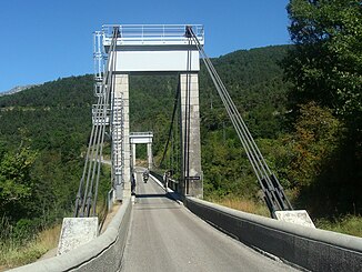
The Pont de Brion bridge |
||
The Ébron is a river in France that runs in the Isère department in the Auvergne-Rhône-Alpes region . It rises in the Trièves landscape , on the southern flank of the Tête de la Cavale summit , in the municipality of Tréminis , generally drains in a north-westerly direction and flows after 32 kilometers at the municipal boundary of Lavars and Treffort as a left tributary into the Drac , which here becomes the Lac de Monteynard-Avignonet is dammed. In the middle reaches the Ébron forms the eastern border of the Vercors Regional Nature Park over a distance of about 10 kilometers .
Places on the river
Attractions
- The cable-stayed suspension bridge Pont de Brion spans the Ébron just before its mouth on the D34 department road .
Web links
Commons : Ébron - collection of images, videos and audio files
Individual evidence
- ↑ Source geoportail.gouv.fr
- ↑ estuary geoportail.gouv.fr
- ↑ a b The information on the length of the river is based on the information about the Ébron at SANDRE (French), accessed on January 25, 2013, rounded to full kilometers.

