Chartreuse Regional Natural Park
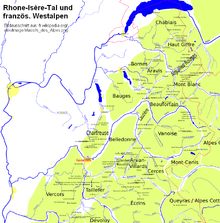
The Chartreuse Regional Nature Park ( French: Parc naturel régional de Chartreuse ) is located in the French region of Auvergne-Rhône-Alpes and includes parts of the Savoie and Isère departments . It extends roughly north of Grenoble and is bordered to the east and south by the Isère River . In the northeast it joins the Regional Nature Park Massif des Bauges , in the southwest the Regional Nature Park Vercors . In the eastern section of the park is the eponymous Chartreuse mountain range .
Park management
The nature park was founded on May 6, 1995. Today it covers an area of around 76,700 hectares. The park administration is based in Saint-Pierre-de-Chartreuse ( 45 ° 20 ′ 28 ″ N , 5 ° 48 ′ 58 ″ E, ), where the "Maison du Parc" is located. 60 municipalities with a catchment area of around 50,000 inhabitants form the park; the cities of Grenoble , Chambéry and Voiron outside the park are also associated as access points.
Larger places in the park
- Chapareillan
- Les Marches
- Miribel-les-Échelles
- Saint-Baldoph
- Saint-Etienne-de-Crossey
- Saint-Hilaire-du-Touvet
- Saint-Laurent-du-Pont
- Vimines
In the agglomeration north of Grenoble and in the Isère Valley, some cities have areas of the nature park apart from their settlement and infrastructure zones. Here are some examples:
Landscapes
The Chartreuse Regional Nature Park is geologically located in the French Limestone Alps . The highest point is the 2082 meter high Chamechaude mountain peak .
Due to its structure, the area can be divided into the following landscapes:
- Haute Chartreuse

The Haute Chartreuse is the actual mountain range, which is characterized by steep terrain and extensive forest areas. It forms a landscape mosaic where karst landscapes , long rock bands , high forests and open alpine meadows alternate. The under nature conservation standing main ridge on the eastern edge of the mountain range is a massive wall before the massive steep breaks into Isèretal that here as Grésivaudan is called. To the west, the mountains drop more gently, the small high valley, which extends in between in a north-south direction, is a little sweeter and the green heart of the Chartreuse. The two rivers Guiers Mort and Guiers Vif have dug deep gorges here and drain to the west down into the hilly Chartreuse foreland . Despite the diverse karst phenomena, there are occasional wetlands with a strong ecological value. The area is characterized by a particularly rich flora and fauna . This is the preferred habitat for roe deer , wild boars , stags , mouflons and chamois .
- Chartreuse foreland
The Chartreuse foreland (French: Avant-Pays de Chartreuse or Moyenne Chartreuse ) offers more open landscapes at an altitude of around 500 meters. They form the basis for human settlement in this area and its agricultural and craft use. The mother monastery of the Carthusian order has found a suitable place here in the quiet of the remote mountain world. The presence of the monks for almost 1000 years has shaped the local civilization and you can still recognize a large number of buildings that are related to their fields of activity. The herbal liqueur Chartreuse Vert , which is still made by the Carthusian monks in Voiron , is very well known . The Carthusians (French: Chartreuse ) are also the namesake for the entire landscape.
- Piémont de Chartreuse
This area is located in the extreme north-east of the nature park, in the vicinity of Les Marches . The area is largely alluvial land of the Isère at an altitude range of 200 to 400 meters. It differs from the other areas of the nature park because it is particularly viticulture that is practiced here.


