
Cognin
| Cognin | ||
|---|---|---|
.svg)
|
|
|
| region | Auvergne-Rhône-Alpes | |
| Department | Savoie | |
| Arrondissement | Chambery | |
| Canton | Chambery-3 | |
| Community association | Chambéry Métropole-Cœur des Bauges | |
| Coordinates | 45 ° 34 ' N , 5 ° 54' E | |
| height | 269-451 m | |
| surface | 4.48 km 2 | |
| Residents | 6,204 (January 1, 2017) | |
| Population density | 1,385 inhabitants / km 2 | |
| Post Code | 73160 | |
| INSEE code | 73087 | |
| Website | www.cognin.fr | |
 Panorama of Cognin and Chambéry |
||

Cognin is a commune with 6204 inhabitants (at January 1, 2017) in the Savoie department in the region of Auvergne Rhône-Alpes . Administratively it is assigned to the Arrondissement of Chambéry and the Canton of Chambéry-3 .
geography
location
Cognin is a suburb of the city of Chambéry and is located about 40 kilometers north of Grenoble , about 80 kilometers southeast of Lyon and about 20 kilometers south of Annecy . The center of the village is located at 292 m in the Hyère valley . The neighboring communities are Chambéry in the north and east, Jacob-Bellecombette in the south-east, Saint-Cassin and Montagnole in the south, Vimines in the south-west and Saint-Sulpice in the west .
topography
Cognin is located between the two mountains of the Jura and the Alps at the transition from the Chaîne de l'Épine , the southernmost anticline of the Jura, to the pre-Alpine limestone massif of the Chartreuse . The lower part of Cognin extends far into the alluvial plain of Chambéry and forms a complete development with the city. The southern and western parts of the 4.48 km 2 municipality reach the gently sloping foothills of the Chartreuse and are predominantly agricultural. The municipality is partly in the Chartreuse Regional Nature Park .
climate
The average temperature in 2010 was 11.1 ° C. In the year mentioned there were 1950 hours of sunshine, 1136 millimeters of rain, it had snowed on 20 days, there was a thunderstorm on 30 days and it was foggy on 27 days.
history
Finds of the remains of a Gallo-Roman villa during construction work in the center of Cognin in the 1970s showed early settlement in the area of today's municipality.
In the High Middle Ages the place is first mentioned by name as Choninum and Cohonnium (around 1100), later as Cognis (1232). In the Middle Ages, Cognin formed a small lordship that first belonged to the manor house of Montfort, then from 1563 to 1707 to the Baronnie Montfort in the area of today's municipality of Saint-Sulpice. In the 15th and 16th centuries, the parish was subject to tax in the diocese of Grenoble.
Attractions
Several old structures can be seen in Cognin. These include the castles and palaces Château de Montcharvin , Château de Villeneuve , Château de Salins , Château de Martinel as well as the Église Saint-Pierre church and the remains of a Gallo-Roman villa.
The old commercial canal Canal des arts et l'atelier de l'eau and the park and farm Parc et la ferme du Foreza are also worth seeing .
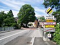
Entrance 
center 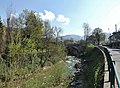
Hyères river in Cognin 
Château de Montcharvin


population
| Population development | |
|---|---|
| year | Residents |
| 1962 | 3.143 |
| 1968 | 3,995 |
| 1975 | 5,397 |
| 1982 | 6,085 |
| 1990 | 5,779 |
| 1999 | 5,900 |
| 2006 | 5,874 |
| 2011 | 5,920 |
Around 1800 Cognin had 651 inhabitants. After the population fluctuated between 1,000 and 1,200 in the second half of the 19th century, it rose steadily in the 20th century. Due to the development to the suburb of Chambéry, the community grew rapidly in the 1970s to almost 6000 inhabitants and then stagnated at this size. Today the community has 6,204 inhabitants (as of January 1, 2017).
Economy and Infrastructure
Cognin is located on the department road D 1006 and the former national road N6 , which leads from Chambéry to Entre-deux-Guiers . A connection to the Chambéry city motorway ( N201 ) around 5 km away connects Cognin with the regional motorways A 41 and A 43 . The nearest train station is the Chambéry-Challes-les-Eaux SNCF station in Chambéry.
Web links
Individual evidence
- ↑ J. Pernon: Une grande villa gallo-romaine à Cognin, près de Chambery . In: Archéologia . No. 103 , 1977, pp. 14-23 (French).
- ^ JJ Vernier: Dictionnaire topographique du département de la Savoie . Imprimerie Savoisienne, 1896, p. 327, 328 (French, bnf.fr [accessed January 19, 2014]).
- ↑ a b Cognin - notice communale. In: cassini.ehess.fr. Retrieved September 5, 2014 (French, INSEE population from 1968 ).
- ↑ French Statistics Institute ( www.insee.fr )