Montmélian
| Montmélian | ||
|---|---|---|

|
|
|
| region | Auvergne-Rhône-Alpes | |
| Department | Savoie | |
| Arrondissement | Chambery | |
| Canton | Montmélian (main town) | |
| Community association | Coeur de Savoie | |
| Coordinates | 45 ° 30 ' N , 6 ° 3' E | |
| height | 256-1,200 m | |
| surface | 5.69 km 2 | |
| Residents | 4,123 (January 1, 2017) | |
| Population density | 725 inhabitants / km 2 | |
| Post Code | 73800 | |
| INSEE code | 73171 | |
| Website | www.montmelian.com | |
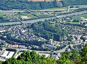
 View of Montmélian from the Rocher du Guet |
||
Montmélian is a French municipality with 4123 inhabitants (as of January 1 2017) in the department of Savoie in the region of Auvergne Rhône-Alpes . Montmélian is the main town ( chef-lieu ) of the canton of Montmélian in the Arrondissement of Chambéry . The inhabitants are called Montmélianais .
geography
Montmélian is located in the Combe de Savoie in the Grésivaudan Valley on the right bank of the Isère about 10 kilometers south-east of Chambéry . Montmélian is surrounded by the neighboring communities of La Thuile in the north, Cruet in the northeast, Arbin in the east, La Chavanne in the southeast, Sainte-Hélène-du-Lac in the south and Porte-de-Savoie with Francin in the west. The community is located within the Massif des Bauges Regional Nature Park . The former national routes 6 and 523 run through the municipality .
Montmélian is located in the Savoy wine region . The white wines are the Roussette de Savoie and the white, rosé and red wine Vin de Savoie .
history
For the Dukes of Savoy, the town of Montmélian with the Miolans castle complex was of considerable strategic importance. At the end of the 12th century the family resided in Montmélian. The citadel was known throughout Europe in the 15th century. In 1600 the battle of Montmélian between the Duchy of Savoy and the Kingdom of France took place here.
Population development
| year | 1962 | 1968 | 1975 | 1982 | 1990 | 1999 | 2006 | 2017 |
| Residents | 1,583 | 2,517 | 3,585 | 4.016 | 3,930 | 3,926 | 3,933 | 4123 |
Attractions
- Montmélian Church, built in the 14th century, renovated in the 18th and 19th centuries
- Capuchin Convent of 1594
- Miolan's castle from the 11th century, razed by Louis XIV in 1706, monument historique since 1944
- Pérouse castle from the 13th century, the Lord of Pérouse is mentioned for the first time in 1306, destroyed by a wall collapse at the beginning of the 20th century
- Town hall, monument historique since 1949
- Morens bridge over the Isère, built in the 17th century from 1669 to 1684, rebuilt in the 19th century, monument historique since 1985
Parish partnership
A partnership has existed with the German municipality of Höchst in the Odenwald in Hesse since 1966.
Personalities
- Amadeus IV of Savoy (1197–1253), Count of Maurienne and Savoy
- Thomas II of Savoy (1199–1259), Count of Flanders and Hainaut, Count of Savoy
- Jean Minjoz (1904–1987), politician, State Secretary (1946/47, 1956/57)
Web links
Individual evidence
- ↑ Montmélian - notice communale. In: cassini.ehess.fr. Retrieved August 18, 2014 (French).


